|
search place name
|
||
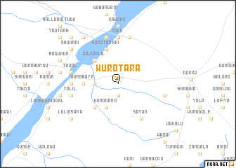
Wuro Tara (Gongola, Nigeria)Wuro Tara is a town in the Gongola region of Nigeria. An overview map of the region around Wuro Tara is displayed below.
regional and 3d topo map of Wuro Tara, Nigeria ::
Wuro Tara airports ::
The nearest airport is JOS - Jos Yakubu Gowon, located 236.1 km south west of Wuro Tara.
Other airports nearby include YOL - Yola (259.1 km south east), Nearby towns ::
Buro Lawal (1.9km south) //
Bulbul (3.6km west) //
Wuro Dama (4.1km south west) //
Gajigala (5.2km north west) //
Gale (5.2km south west) //
Wuro Baye (5.5km west) //
Wuro Taraki (5.9km north) //
Sayum (6.6km south east) //
Dashi (6.6km south east) //
Yole (7.4km north) //
Gombe Aba (7.3km west) //
Wuro Bongu (7.6km north) //
Hashidu (7.6km north) //
Gidan Bani (7.5km east) //
Towal (7.5km west) //
Yolil (7.5km west) //
Wuro Mareji (9.2km north west) //
Mararaba (9.2km north west) //
Shuwari (9.2km north west) //
Lulin Sama (9.2km south west) //
Hashmeri (10.4km north west) //
[all distances 'as the bird flies' and approximate] 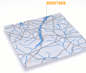 Places with similar names to Wuro Tara, Nigeria ::
Disclaimer :: Information on this page comes without warranty of any kind |
||
|
Where is Wuro Tara? Elevation and coordinates ::
Latitude (lat): 10°49'0"N Longitude (lon): 10°40'0"E
Elevation (approx.): 375m (map arrows pan, magnifying glasses zoom) |
||
|
Visiting Wuro Tara? Hotel/Accommodation ::
Book a hotel in Wuro Tara Travel Guide ::
Buy a travel guide for Nigeria rental cars ::
car rental offers GPS waypoint ::
download a GPX waypoint (PoI) of Wuro Tara for your GPS receiver
|
||