|
search place name
|
||
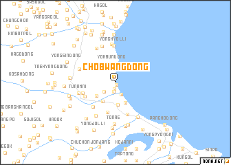
Chŏbwang-dong (Hamgyŏng, Korea, North)Chŏbwang-dong is a town in the Hamgyŏng region of Korea, North. An overview map of the region around Chŏbwang-dong is displayed below.
regional and 3d topo map of Chŏbwang-dong, Korea, North ::
Nearby towns ::
Un'gong-ni (0.4km south) //
Paegumi (1.1km south) //
Sŏmnae (1.6km south) //
Yongam-dong (2.1km south) //
Hado-dong (2.0km south west) //
Yŏmbun-dong (3.1km north) //
Chunghyang-dong (3.5km south) //
Ŏrang-ŭp (3.7km south) //
P'yŏngnam-dong (3.5km south west) //
Sangdo-dong (3.2km south west) //
Puam-ni (5.0km south) //
Simun-dong (4.8km south west) //
Chungp'yŏng (4.4km south west) //
Hoemul-li (5.4km south) //
Ch'ilban-dong (4.4km south west) //
Yonghyŏl-li (6.0km north) //
Chŏnsan (6.2km north) //
Tunam-ni (4.8km west) //
Yŏngwŏn-dong (4.9km north west) //
Oryu-dong (6.1km north) //
Oha-dong (5.9km south west) //
Namsŏk (6.0km north west) //
Namsong-dong (6.2km south east) //
Tonae (6.7km south) //
Haryong (7.1km south) //
Ch'ŏllyŏn-dong (7.2km south) //
Hwau-dong (7.4km south) //
Wŏn-dong (5.6km west) //
Osang-dong (6.9km south west) //
[all distances 'as the bird flies' and approximate]  Places with similar names to Chŏbwang-dong, Korea, North :: Disclaimer :: Information on this page comes without warranty of any kind |
||
|
Where is Chŏbwang-dong? Elevation and coordinates ::
Latitude (lat): 41°28'50"N Longitude (lon): 129°39'9"E
Elevation (approx.): 4m (map arrows pan, magnifying glasses zoom) |
||
|
Visiting Chŏbwang-dong? Hotel/Accommodation ::
Book a hotel in Chŏbwang-dong Travel Guide ::
rental cars ::
car rental offers GPS waypoint ::
download a GPX waypoint (PoI) of Chŏbwang-dong for your GPS receiver
|
||