|
search place name
|
||
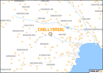
Ch'ŏllyŏn-gol (Hamgyŏng, Korea, North)Ch'ŏllyŏn-gol is a town in the Hamgyŏng region of Korea, North. An overview map of the region around Ch'ŏllyŏn-gol is displayed below.
regional and 3d topo map of Ch'ŏllyŏn-gol, Korea, North ::
Nearby towns ::
Cha-dong (1.4km north west) //
Nojŏn-gol (1.9km north west) //
Kalbat-kol (1.9km west) //
Sangch'ang-dong (2.8km north east) //
Okch'ŏl-li (2.7km north west) //
P'ungnyŏl-li (2.6km east) //
Pyŏng-ch'on (3.6km south east) //
Igok (3.9km south) //
Kŭmch'ŏn-dong (3.9km south) //
Ha-ch'on (3.2km east) //
Tong-ch'on (3.3km west) //
Kŭmji-dong (3.6km south east) //
Nan-dong (4.3km south west) //
Kat'o-dong (4.8km south) //
Paek-tong (4.1km north west) //
Namnyanggae (4.0km east) //
Chung-ch'on (4.2km west) //
Sap'yŏng-ch'on (5.1km north east) //
Hap'yŏng-ch'on (5.5km north) //
Sunam-ch'on (4.3km east) //
Songp'yŏng (5.5km north) //
Hach'ang-dong (4.8km north east) //
Chikso-dong (4.6km north west) //
Sunam-ch'on (5.8km north) //
Chŏngsu-dong (6.0km north) //
Songhŭng-ni (5.2km north east) //
Sosan-dong (6.0km south) //
Sangp'yŏng-ni (6.1km north) //
Hanam-ch'on (6.3km north) //
[all distances 'as the bird flies' and approximate] 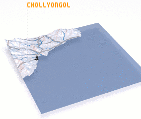 Places with similar names to Ch'ŏllyŏn-gol, Korea, North :: Disclaimer :: Information on this page comes without warranty of any kind |
||
|
Where is Ch'ŏllyŏn-gol? Elevation and coordinates ::
Latitude (lat): 40°43'36"N Longitude (lon): 129°7'14"E
Elevation (approx.): 119m (map arrows pan, magnifying glasses zoom) |
||
|
Visiting Ch'ŏllyŏn-gol? Hotel/Accommodation ::
Book a hotel in Ch'ŏllyŏn-gol Travel Guide ::
rental cars ::
car rental offers GPS waypoint ::
download a GPX waypoint (PoI) of Ch'ŏllyŏn-gol for your GPS receiver
|
||