|
search place name
|
||
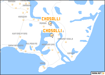
Chosal-li (Najin Sŏnbong-si, Korea, North)Chosal-li is a town in the Najin Sŏnbong-si region of Korea, North. An overview map of the region around Chosal-li is displayed below.
regional and 3d topo map of Chosal-li, Korea, North ::
Chosal-li airports ::
The nearest airport is VVO - Vladivostok Knevichi, located 168.8 km north east of Chosal-li.
Nearby towns ::
Sunjŏndae (2.0km north east) //
Hongsangp'o (3.8km south) //
Chosal-li (4.2km north) //
Hwangŏp'o (4.4km south) //
(( Krasnoye Selo )) (3.9km south east) //
Pup'o-ri (4.6km north west) //
T'ori-dong (5.5km south) //
Tuman'gang-nodongjagu (6.1km north) //
Khasan (6.5km north) //
Sŏp'ohang-dong (6.8km south west) //
Kulp'o-dong (6.6km south west) //
Kulp'o-dong (6.4km south west) //
Namjŭngsan-dong (7.4km north west) //
Chŭngsan-dong (8.2km north west) //
(( Kanguy )) (8.5km south east) //
[all distances 'as the bird flies' and approximate] 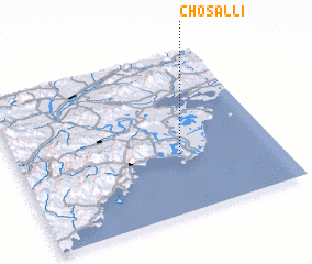 Places with similar names to Chosal-li, Korea, North ::
Disclaimer :: Information on this page comes without warranty of any kind |
||
|
Where is Chosal-li? Elevation and coordinates ::
Latitude (lat): 42°21'58"N Longitude (lon): 130°37'54"E
Elevation (approx.): 10m (map arrows pan, magnifying glasses zoom) |
||
|
Visiting Chosal-li? Hotel/Accommodation ::
Book a hotel in Chosal-li Travel Guide ::
rental cars ::
car rental offers GPS waypoint ::
download a GPX waypoint (PoI) of Chosal-li for your GPS receiver
|
||