|
search place name
|
||
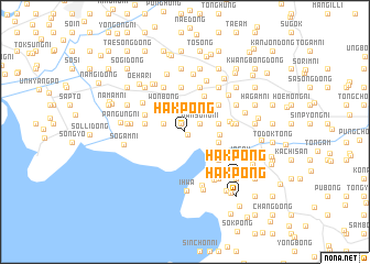
Hakpong (P'yŏngan, Korea, North)Hakpong is a town in the P'yŏngan region of Korea, North. An overview map of the region around Hakpong is displayed below.
regional and 3d topo map of Hakpong, Korea, North ::
Hakpong airports ::
The nearest airport is FNJ - Pyongyang Intl, located 118.1 km south east of Hakpong.
Nearby towns ::
Hakso-ri (0.3km south east) //
Namhyŏn (0.9km north) //
Namsong-ni (1.4km north east) //
Ponghwang-dong (1.9km north west) //
Tongjŏng-ni (1.9km north west) //
Sŏsŏk-tong (2.5km north) //
Tonghyŏn (2.7km north) //
Sŏhyŏn (2.7km north) //
Haeam (2.7km north) //
Ch'ŏngo (2.9km north east) //
Songjŏng (2.9km north east) //
Sinjungsan (2.9km north east) //
Tajŏng-dong (2.7km east) //
Changhŭng-ni (3.2km north west) //
Wŏnbong (3.2km north west) //
Inp'yŏng (3.2km north west) //
Changsong (3.2km north west) //
Sŏn-ni (2.8km east) //
Sŏkt'an (2.8km east) //
Hwa-dong (2.7km east) //
Hasŏng-ni (3.9km north east) //
Tangjŏng-ni (3.2km west) //
Tongam (3.2km west) //
Tongsŏk-tong (3.7km north east) //
Chuŭi-ri (3.5km north west) //
Sin'got-tong (3.9km south east) //
Nambal (4.5km north) //
Sangho-dong (4.5km north) //
Tangbong (3.7km east) //
[all distances 'as the bird flies' and approximate] 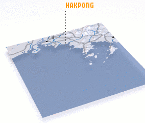 Places with similar names to Hakpong, Korea, North ::
Disclaimer :: Information on this page comes without warranty of any kind |
||
|
Where is Hakpong? Elevation and coordinates ::
Latitude (lat): 39°50'33"N Longitude (lon): 124°33'11"E
Elevation (approx.): 4m (map arrows pan, magnifying glasses zoom) |
||
|
Visiting Hakpong? Hotel/Accommodation ::
Book a hotel in Hakpong Travel Guide ::
rental cars ::
car rental offers GPS waypoint ::
download a GPX waypoint (PoI) of Hakpong for your GPS receiver
|
||