|
search place name
|
||
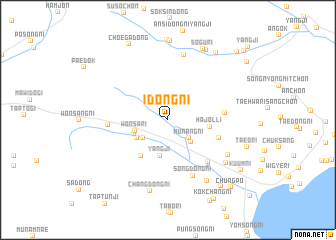
Idŏng-ni (Hamgyŏng, Korea, North)Idŏng-ni is a town in the Hamgyŏng region of Korea, North. An overview map of the region around Idŏng-ni is displayed below.
regional and 3d topo map of Idŏng-ni, Korea, North ::
Nearby towns ::
Munang-ni (2.7km south east) //
Sodunji (3.0km south west) //
Angsidong-ni (3.1km south east) //
Wŏnsa-ri (3.1km south west) //
Ko-ch'on (3.3km south west) //
Yangji (4.0km south) //
Wŏndong-ni (3.3km south west) //
Hajŏl-li (3.6km east) //
Sang-ch'on (4.6km south west) //
Chŏlgorŏgu (4.8km south east) //
Sang-ch'on (4.9km east) //
Songnodaeri (5.8km south east) //
Songdong-ni (6.0km south east) //
Wŏnjŏl-li (5.1km west) //
Sŏngdong-ni (6.6km south) //
Pŏmsŏk-tong (7.4km north) //
Handang-ni (6.4km south east) //
Tŏksŏng-ni (7.5km south east) //
Hayujŏng-ni (6.9km south east) //
Changdong-ni (8.1km south) //
Samgŏ-ri (8.8km north) //
Sŏgu-ri (8.4km north) //
Kodŏk-ch'on (8.4km north east) //
Subuk-ch'on (8.5km north east) //
Taeo-ri (7.4km south east) //
Ch'oega-dong (9.1km north) //
Ansi-ri (8.7km south east) //
Kuŭm-ni (8.4km south east) //
Kokch'ang-ni (9.6km south east) //
[all distances 'as the bird flies' and approximate] 
Disclaimer :: Information on this page comes without warranty of any kind |
||
|
Where is Idŏng-ni? Elevation and coordinates ::
Latitude (lat): 40°22'50"N Longitude (lon): 128°32'3"E
Elevation (approx.): 123m (map arrows pan, magnifying glasses zoom) |
||
|
Visiting Idŏng-ni? Hotel/Accommodation ::
Book a hotel in Idŏng-ni Travel Guide ::
rental cars ::
car rental offers GPS waypoint ::
download a GPX waypoint (PoI) of Idŏng-ni for your GPS receiver
|
||