|
search place name
|
||
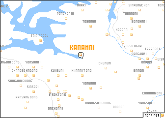
Kanam-ni (Korea, North)Kanam-ni is a town in Korea, North. An overview map of the region around Kanam-ni is displayed below.
regional and 3d topo map of Kanam-ni, Korea, North ::
Kanam-ni airports ::
The nearest airport is FNJ - Pyongyang Intl, located 142.4 km south of Kanam-ni.
Nearby towns ::
Hwarak-tong (3.7km south) //
Sam-dong (4.7km south west) //
Chung-ni (4.5km south east) //
Kŭmbu-ri (5.6km south west) //
Ŭnsan-dong (5.6km south west) //
Yongam-ni (6.8km south) //
T'osŏng-ni (7.5km north) //
Halsŏng-ni (7.5km north) //
Yŏngch'ŏn-dong (7.3km south east) //
Sinp'yŏng-ni (7.0km north east) //
Chajak-tong (7.1km north east) //
Chungdan-dong (6.5km south east) //
Taeda-dong (7.9km south) //
Taedae-ri (7.9km south west) //
Handae-dong (7.5km south west) //
Sodŏng-ni (8.8km south) //
Tŏkp'ung-dong (8.7km south) //
Sakchu-ŭp (7.7km south west) //
T'angno-dong (8.5km south west) //
Kŭmya-ri (7.7km north east) //
Ch'ŏngjŏn-dong (9.3km south west) //
[all distances 'as the bird flies' and approximate] 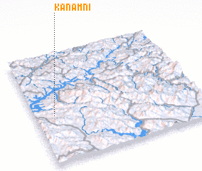 Places with similar names to Kanam-ni, Korea, North ::
Disclaimer :: Information on this page comes without warranty of any kind |
||
|
Where is Kanam-ni? Elevation and coordinates ::
Latitude (lat): 40°26'0"N Longitude (lon): 125°7'0"E
Elevation (approx.): 204m (map arrows pan, magnifying glasses zoom) |
||
|
Visiting Kanam-ni? Hotel/Accommodation ::
Book a hotel in Kanam-ni Travel Guide ::
rental cars ::
car rental offers GPS waypoint ::
download a GPX waypoint (PoI) of Kanam-ni for your GPS receiver
|
||