|
search place name
|
||
Kunmak-tong (Hamgyŏng, Korea, North)Kunmak-tong is a town in the Hamgyŏng region of Korea, North. An overview map of the region around Kunmak-tong is displayed below.
regional and 3d topo map of Kunmak-tong, Korea, North ::
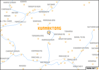
Nearby towns ::
Hwanggong-ni (3.0km south) //
Hwanggokchung-ch'on (3.4km south) //
Soksa-dong (3.1km east) //
Tongan-dong (3.5km south west) //
Pongsu-dong (4.5km north) //
Ssari-gol (5.3km north west) //
Ongnyŏn-dong (5.3km south east) //
Tohwasu (5.7km east) //
Wŏnhŭng-ni (7.9km north) //
Kŏnp'o-dong (8.0km south west) //
Tŏgyongdŏng-ni (8.3km north west) //
Ch'oesin (8.4km south east) //
Songi-dong (8.8km south east) //
Ŭmp'yŏng-ni (10.4km north west) //
Sangnam-ni (10.1km north west) //
Toch'ang (10.3km north west) //
[all distances 'as the bird flies' and approximate] 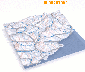 Places with similar names to Kunmak-tong, Korea, North ::
// Kunmak-tong (KR)
// Kanim-gahtawng (MM)
Disclaimer :: Information on this page comes without warranty of any kind |
||
|
Where is Kunmak-tong? Elevation and coordinates ::
Latitude (lat): 40°46'46"N Longitude (lon): 128°36'55"E
Elevation (approx.): 929m (map arrows pan, magnifying glasses zoom) |
||
|
Visiting Kunmak-tong? Hotel/Accommodation ::
Book a hotel in Kunmak-tong Travel Guide ::
rental cars ::
car rental offers GPS waypoint ::
download a GPX waypoint (PoI) of Kunmak-tong for your GPS receiver
|
||