|
search place name
|
||
Kyŏngsŏng-ŭp (Hamgyŏng, Korea, North)Kyŏngsŏng-ŭp is a town in the Hamgyŏng region of Korea, North. An overview map of the region around Kyŏngsŏng-ŭp is displayed below.
regional and 3d topo map of Kyŏngsŏng-ŭp, Korea, North ::
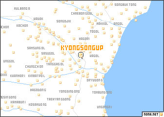
Nearby towns ::
Osongp'yŏng (0.6km north) //
Hamyŏl-li (0.7km south west) //
Ch'ang-ch'on (1.8km north) //
Wŏl-ch'on (1.8km north) //
Namjang (1.9km south) //
Hapch'ŏn (1.7km south west) //
Hyangnam-gol (2) (2.1km north east) //
Sŏngjo-gol (2.5km north) //
Chuŭl-li (2.6km north) //
Sae-mal (2.2km north west) //
Che-ch'on (2.6km north) //
P'yŏngdŏk (2.0km west) //
Ap-maŭl (2.3km north west) //
Yongch'ŏl-lodongjagu (2.9km south) //
Wagol (2.3km east) //
Chŏnggol (2.3km east) //
Tŏksan (2.6km south west) //
Sangjangdŏk (3.2km south) //
Ŏjaeng-gol (3.4km north) //
Hajangdŏk (3.4km south) //
Irhyang-ni (2.7km south east) //
Tunjip'o (3.0km south west) //
Hagŏri (3.4km north) //
Tunji (3.6km south) //
Yumanhogol (3.3km south east) //
Saengyŏnggangŏgu (4.0km south) //
Sugok (3.1km west) //
Hyangnam-gol (3.6km north east) //
Haonp'o-ri (3.5km north west) //
[all distances 'as the bird flies' and approximate] 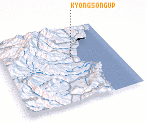 Places with similar names to Kyŏngsŏng-ŭp, Korea, North :: Disclaimer :: Information on this page comes without warranty of any kind |
||
|
Where is Kyŏngsŏng-ŭp? Elevation and coordinates ::
Latitude (lat): 41°35'16"N Longitude (lon): 129°36'22"E
Elevation (approx.): 16m (map arrows pan, magnifying glasses zoom) |
||
|
Visiting Kyŏngsŏng-ŭp? Hotel/Accommodation ::
Book a hotel in Kyŏngsŏng-ŭp Travel Guide ::
rental cars ::
car rental offers GPS waypoint ::
download a GPX waypoint (PoI) of Kyŏngsŏng-ŭp for your GPS receiver
|
||