|
search place name
|
||
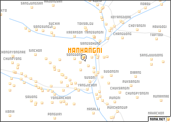
Manhang-ni (Hamgyŏng, Korea, North)Manhang-ni is a town in the Hamgyŏng region of Korea, North. An overview map of the region around Manhang-ni is displayed below.
regional and 3d topo map of Manhang-ni, Korea, North ::
Nearby towns ::
Song-dong (0.9km west) //
Nagwŏl-li (1.1km south east) //
Orip'yŏng (1.3km north east) //
Sŏŭm-dong (2.1km south) //
Kujungbi (2.0km south east) //
Song-dong (1.9km west) //
Sŏhung-ni (2.5km north east) //
Ŏŭl-li (2.3km north east) //
Hajangnae (2.1km east) //
Chuŭidong-ni (2.4km north east) //
Tŏksŏng-ŭp (2.8km south east) //
Sangsŏhŭng (3.0km north) //
Chukchŏn-ni (3.3km south east) //
Ogu (3.5km south east) //
Chungjangnae (3.2km east) //
Susŏ-ri (4.6km south) //
Sangjangnae (3.7km east) //
Kumip'o (4.4km south east) //
Chang-ch'on (5.1km south) //
Kŭm-ch'on (4.9km south west) //
Yangnyu (5.0km north east) //
Yangp'yŏng-ni (5.4km north) //
Sinhŭng-ni (4.3km west) //
Kang-ch'on (4.9km south west) //
Yangsŭng-ni (5.6km north) //
Han-ch'on (5.5km south west) //
Pak-ch'on (4.9km south west) //
Kaeamsŏm (5.8km north) //
Imjadong-ni (4.9km south west) //
[all distances 'as the bird flies' and approximate]  Places with similar names to Manhang-ni, Korea, North ::
// Manhang-ni (KP)
// Manhŭng-ni (KP)
// Munhŭng-ni (KP)
// Munhŭng-ni (KP)
// Munhŭng-ni (KP)
// Munhŭng-ni (KP)
// Munhŭng-ni (KP)
// Manhangana (MZ)
// Manhungane (MZ)
// Munhangana (MZ)
Disclaimer :: Information on this page comes without warranty of any kind |
||
|
Where is Manhang-ni? Elevation and coordinates ::
Latitude (lat): 40°20'28"N Longitude (lon): 128°14'58"E
Elevation (approx.): 174m (map arrows pan, magnifying glasses zoom) |
||
|
Visiting Manhang-ni? Hotel/Accommodation ::
Book a hotel in Manhang-ni Travel Guide ::
rental cars ::
car rental offers GPS waypoint ::
download a GPX waypoint (PoI) of Manhang-ni for your GPS receiver
|
||