|
search place name
|
||
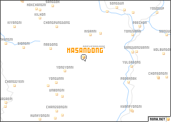
Masan-dong (Hamgyŏng, Korea, North)Masan-dong is a town in the Hamgyŏng region of Korea, North. An overview map of the region around Masan-dong is displayed below.
regional and 3d topo map of Masan-dong, Korea, North ::
Masan-dong airports ::
The nearest airport is FNJ - Pyongyang Intl, located 95.0 km west of Masan-dong.
Other airports nearby include GMP - Seoul Gimpo (217.4 km south), SHO - Sokch'o Sokcho (224.1 km south east), Nearby towns ::
Paeksan-dong (2.6km north east) //
Yongyŏn-ni (4.1km south west) //
Misam-ni (5.7km north) //
Sinhŭng-ni (6.5km north east) //
Yongun-ni (6.8km south west) //
Nae-dong (6.5km north west) //
Sanch'ang (8.8km south west) //
Unbong-ni (8.8km south west) //
Changp'ung-dong (8.9km north west) //
Pangmong-ni (8.9km north west) //
Sŏmam-maŭl (8.3km south west) //
[all distances 'as the bird flies' and approximate]  Places with similar names to Masan-dong, Korea, North ::
// Masanteng (ZA)
// Maesan-dong (KP)
// Maesan-dong (KP)
// Maesan-dong (KP)
// Masan-dong (KP)
// Masan-dong (KP)
// Masan-dong (KP)
// Masan-dong (KP)
// Masan-dong (KP)
// Masan-dong (KP)
Disclaimer :: Information on this page comes without warranty of any kind |
||
|
Where is Masan-dong? Elevation and coordinates ::
Latitude (lat): 39°30'57"N Longitude (lon): 126°42'23"E
Elevation (approx.): 629m (map arrows pan, magnifying glasses zoom) |
||
|
Visiting Masan-dong? Hotel/Accommodation ::
Book a hotel in Masan-dong Travel Guide ::
rental cars ::
car rental offers GPS waypoint ::
download a GPX waypoint (PoI) of Masan-dong for your GPS receiver
|
||