|
search place name
|
||
Namgok (Hamgyŏng, Korea, North)Namgok is a town in the Hamgyŏng region of Korea, North. An overview map of the region around Namgok is displayed below.
regional and 3d topo map of Namgok, Korea, North ::
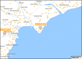
Nearby towns ::
Samgŭnjin (0.8km north east) //
Kan-ch'on (1.0km north) //
Hankkŭt (1.0km south west) //
Yujin (1.1km west) //
Hanch'ŏn (1.9km north) //
Toryong-dong (1.8km west) //
Yang-ch'on (2.6km north) //
Ihyŏn-ch'on (2.9km north) //
Ch'ang-ch'on (2.9km north) //
Yongam-dong (2.9km north east) //
Sŏkho-ri (3.7km north) //
Hurijin (3.2km north west) //
Yongsan-ch'on (4.0km north) //
Haep'yŏng-dong (3.4km west) //
Sumyo-dong (4.5km north) //
Tong-ch'on (4.1km north west) //
Haep'yŏngdong-Tae-dong (4.3km north west) //
P'unghyŏn (5.3km north) //
Ch'undong-ni (4.9km north west) //
Kŏmoru (5.7km north east) //
Ŭn'gok (5.3km north west) //
Sap'yŏng (6.0km north east) //
Tangjŏ-ch'on (5.8km north west) //
Yongho-ri (6.4km north) //
Yongp'o-dong (6.7km north) //
Nambŏl (5.6km north west) //
Sangbang-dong (7.3km north) //
Ch'undongdae-dong (6.8km north west) //
Pang-dong (7.8km north) //
[all distances 'as the bird flies' and approximate] 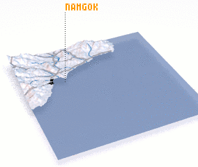 Places with similar names to Namgok, Korea, North ::
// Namakauk (MM)
// Nā-makhkaw (MM)
// Nā-makhkaw (MM)
// Namhkek (MM)
// Namhkok (MM)
// Namhkok (MM)
// Namhkok (MM)
// Namkak (MM)
// Nammawhkü Ga (MM)
// Niemegk (DE)
Disclaimer :: Information on this page comes without warranty of any kind |
||
|
Where is Namgok? Elevation and coordinates ::
Latitude (lat): 40°41'30"N Longitude (lon): 129°18'20"E
Elevation (approx.): 42m (map arrows pan, magnifying glasses zoom) |
||
|
Visiting Namgok? Hotel/Accommodation ::
Book a hotel in Namgok Travel Guide ::
rental cars ::
car rental offers GPS waypoint ::
download a GPX waypoint (PoI) of Namgok for your GPS receiver
|
||