|
search place name
|
||
Paengnyŏn-dong (Hamgyŏng, Korea, North)Paengnyŏn-dong is a town in the Hamgyŏng region of Korea, North. An overview map of the region around Paengnyŏn-dong is displayed below.
regional and 3d topo map of Paengnyŏn-dong, Korea, North ::

Nearby towns ::
Pokhŭng-dong (1.9km north east) //
Hanam-ch'on (3.4km south) //
Yŏngyang-ch'on (3.5km north) //
T'app'yŏng-dong (3.2km north east) //
Panghang-ni (3.5km south east) //
Kŏmunu (3.3km south east) //
P'yŏng-ch'on (3.3km east) //
P'yŏng-ch'on (3.6km south east) //
T'app'yŏngdongt'ap-tong (4.1km north east) //
Ŏbŏk-tong (4.5km north) //
Hoyang-dong (4.4km south) //
Songhŭng-ni (4.4km south) //
Sang-ch'on (3.9km south east) //
Ch'ŏndogi (4.7km north) //
Sap'yŏng-ch'on (4.3km south west) //
Ch'ŏndogi (4.8km north) //
Songp'yŏng (4.2km south west) //
Hadae (3.8km east) //
Sunam-ch'on (4.1km south west) //
Subuk-ch'on (3.9km west) //
Ŏmŏ-dong (5.0km south) //
Hach'ang-dong (5.0km south) //
Hot'ong-ni (4.8km south east) //
Sanggusa (4.0km west) //
Hyŏn-ch'on (5.4km north) //
P'yŏng-ch'on (5.4km south) //
Chung-ch'on (5.0km south east) //
Ha-ch'on (5.2km south east) //
Twi-gol (5.1km north east) //
[all distances 'as the bird flies' and approximate] 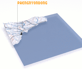 Places with similar names to Paengnyŏn-dong, Korea, North ::
// Pungnyŏn-dong (KP)
// Paengnyŏn-dong (KR)
// Paengnyŏn-dong (KR)
// P'ungnyŏn-dong (KR)
// P'ungnyŏn-dong (KP)
Disclaimer :: Information on this page comes without warranty of any kind |
||
|
Where is Paengnyŏn-dong? Elevation and coordinates ::
Latitude (lat): 40°47'54"N Longitude (lon): 129°10'48"E
Elevation (approx.): 347m (map arrows pan, magnifying glasses zoom) |
||
|
Visiting Paengnyŏn-dong? Hotel/Accommodation ::
Book a hotel in Paengnyŏn-dong Travel Guide ::
rental cars ::
car rental offers GPS waypoint ::
download a GPX waypoint (PoI) of Paengnyŏn-dong for your GPS receiver
|
||