|
search place name
|
||
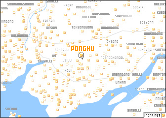
Ponghu (P'yŏngan, Korea, North)Ponghu is a town in the P'yŏngan region of Korea, North. An overview map of the region around Ponghu is displayed below.
regional and 3d topo map of Ponghu, Korea, North ::
Ponghu airports ::
The nearest airport is FNJ - Pyongyang Intl, located 54.1 km south east of Ponghu.
Nearby towns ::
Tongch'ang-ni (1.2km south) //
Pongap (1.2km south west) //
Kinjae (1.0km east) //
Kwangsŏng (1.1km west) //
Anyang-gol (1.4km north west) //
Mipa-dong (1.5km north east) //
Koju (2.2km south) //
Tŏgwŏl-li (2.2km south) //
Yongmu (2.2km south) //
T'osan (2.3km south) //
Konggyŏng-dong (2.4km north) //
Yŏngbŏl-li (2.4km south) //
Tumi-dong (2.6km north east) //
Nŭk-tong (3.0km south) //
Chungso-ri (2.6km south west) //
Sino-ri (2.5km east) //
Tongso-ri (2.9km north west) //
Yongjang (2.6km east) //
Sŏso-ri (3.2km north west) //
Sangso-ri (2.8km west) //
Kusŏng (3.5km south west) //
Ilsil-li (3.0km south west) //
P'iam (3.4km south east) //
Chinbok-tong (3.2km south east) //
Yangji (3.3km south east) //
Paengmisanso-ri (4.0km north) //
Muro-ri (3.9km south) //
Wŏrun-dong (4.1km south) //
Kwangsŏng (3.4km west) //
[all distances 'as the bird flies' and approximate]  Places with similar names to Ponghu, Korea, North ::
Disclaimer :: Information on this page comes without warranty of any kind |
||
|
Where is Ponghu? Elevation and coordinates ::
Latitude (lat): 39°38'21"N Longitude (lon): 125°20'25"E
Elevation (approx.): 25m (map arrows pan, magnifying glasses zoom) |
||
|
Visiting Ponghu? Hotel/Accommodation ::
Book a hotel in Ponghu Travel Guide ::
rental cars ::
car rental offers GPS waypoint ::
download a GPX waypoint (PoI) of Ponghu for your GPS receiver
|
||