|
search place name
|
||
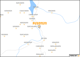
Pusŏng-ni (Korea, North)Pusŏng-ni is a town in Korea, North. An overview map of the region around Pusŏng-ni is displayed below.
regional and 3d topo map of Pusŏng-ni, Korea, North ::
Pusŏng-ni airports ::
The nearest airport is FNJ - Pyongyang Intl, located 185.1 km south west of Pusŏng-ni.
Nearby towns ::
Sangp'yŏng-ni (2.3km north west) //
Nŭpch'ojang (2.8km west) //
Tonae-ri (4.7km north west) //
Hwangch'o-ri (5.7km south) //
Kot'osu (5.7km south) //
Changjin-ŭp (6.1km north west) //
Hagaru-ri (6.2km north west) //
Hongmun-ni (5.9km west) //
Nŭpching-ni (6.8km south west) //
Manp'ung-ni (8.5km south west) //
Paegam-ni (8.5km north east) //
Ch'ukchŏn-ni (9.3km north west) //
Kohŭng-ni (9.3km south east) //
[all distances 'as the bird flies' and approximate] 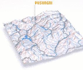 Places with similar names to Pusŏng-ni, Korea, North ::
// Pazin-gôn (MM)
// Pazungon (MM)
// Pescincanna (IT)
// Pisāngan (IN)
// Passiangan (ID)
// Pisangan (ID)
// Pā Sangān (IR)
// P'osang-ni (KP)
// P'osang-ni (KP)
// Posŏng-ni (KP)
Disclaimer :: Information on this page comes without warranty of any kind |
||
|
Where is Pusŏng-ni? Elevation and coordinates ::
Latitude (lat): 40°20'0"N Longitude (lon): 127°17'0"E
Elevation (approx.): 1096m (map arrows pan, magnifying glasses zoom) |
||
|
Visiting Pusŏng-ni? Hotel/Accommodation ::
Book a hotel in Pusŏng-ni Travel Guide ::
rental cars ::
car rental offers GPS waypoint ::
download a GPX waypoint (PoI) of Pusŏng-ni for your GPS receiver
|
||