|
search place name
|
||
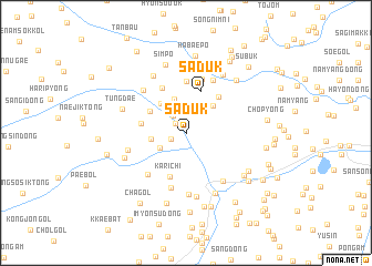
Sadŭk (Hamgyŏng, Korea, North)Sadŭk is a town in the Hamgyŏng region of Korea, North. An overview map of the region around Sadŭk is displayed below.
regional and 3d topo map of Sadŭk, Korea, North ::
Nearby towns ::
Namsŏk (1.2km north west) //
Yumok (1.3km north west) //
Changhang (1.3km south west) //
Sŭngji (2.0km north west) //
Chungp'yŏng-dong (2.5km south west) //
Sandae (2.9km north east) //
Sae-gol (3.1km north) //
Puhwa-ri (3.1km north west) //
Kari-dong (2.7km west) //
Ungjŏm-ni (3.5km north) //
Yosan (3.5km north west) //
Such'im (3.5km north east) //
Sagijŏm (3.5km north west) //
Sadŭk (4.3km north) //
Karich'i (4.5km south) //
Kwŏlp'o (3.6km west) //
Man'gŭmp'o (4.4km north east) //
Sadŏk (4.8km north) //
Tokchang (5.2km north) //
Iman (5.6km north) //
Igadŏgi (5.1km south west) //
Sanga-dong (5.7km south) //
Hariman (5.7km north) //
Iwŏnji-dong (4.7km west) //
P'aeŭidŏk (5.4km north west) //
Yongjŏn-dong (5.6km south east) //
Yongdŏng-ni (6.2km south) //
Sangnyegumi (6.5km south) //
Yŏndae-gol (6.2km north west) //
[all distances 'as the bird flies' and approximate] 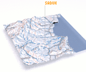 Places with similar names to Sadŭk, Korea, North ::
Disclaimer :: Information on this page comes without warranty of any kind |
||
|
Where is Sadŭk? Elevation and coordinates ::
Latitude (lat): 41°16'10"N Longitude (lon): 129°23'39"E
Elevation (approx.): 258m (map arrows pan, magnifying glasses zoom) |
||
|
Visiting Sadŭk? Hotel/Accommodation ::
Book a hotel in Sadŭk Travel Guide ::
rental cars ::
car rental offers GPS waypoint ::
download a GPX waypoint (PoI) of Sadŭk for your GPS receiver
|
||