|
search place name
|
||
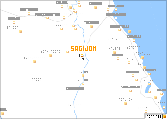
Sagijŏm (Korea, North)Sagijŏm is a town in Korea, North. An overview map of the region around Sagijŏm is displayed below.
regional and 3d topo map of Sagijŏm, Korea, North ::
Sagijŏm airports ::
The nearest airport is SHO - Sokch'o Sokcho, located 49.0 km south east of Sagijŏm.
Other airports nearby include KAG - Kangnung Gangneung (101.8 km south east), SSN - Seoul East Seoul Ab (158.1 km south west), GMP - Seoul Gimpo (169.9 km south west), OSN - Osan Ab (193.8 km south west), Nearby towns ::
Sindae-ri (1.9km north) //
Sabi-ri (3.7km south) //
Changjaeam-gol (3.3km north west) //
Wŏndae (5.6km south) //
Naemyŏl-li (6.9km north) //
Kalbat (5.7km east) //
Kalch'ŏn (5.7km east) //
Yŏnhwa-dong (5.8km west) //
Tŏksan-ni (7.6km north) //
Komisŏng-ni (7.6km south) //
Panjŏn (6.2km east) //
P'ibang (7.7km north) //
Kŏndal (6.1km east) //
Kŏmjang-ni (6.9km north east) //
Karae-gol (7.8km north west) //
Taebong-ni (8.4km north) //
Songhyŏl-li (9.2km north east) //
Chinch'ŏn (10.0km north west) //
[all distances 'as the bird flies' and approximate] 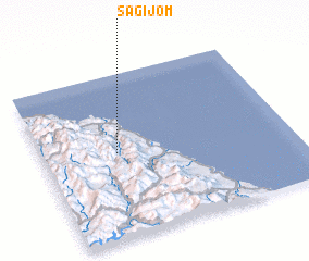 Places with similar names to Sagijŏm, Korea, North ::
Disclaimer :: Information on this page comes without warranty of any kind |
||
|
Where is Sagijŏm? Elevation and coordinates ::
Latitude (lat): 38°31'0"N Longitude (lon): 128°18'0"E
Elevation (approx.): 146m (map arrows pan, magnifying glasses zoom) |
||
|
Visiting Sagijŏm? Hotel/Accommodation ::
Book a hotel in Sagijŏm Travel Guide ::
rental cars ::
car rental offers GPS waypoint ::
download a GPX waypoint (PoI) of Sagijŏm for your GPS receiver
|
||