|
search place name
|
||
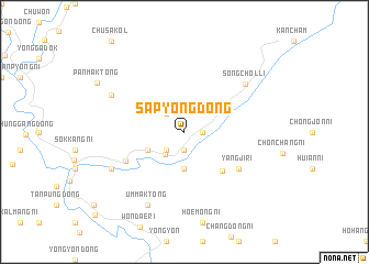
Sap'yŏng-dong (Korea, North)Sap'yŏng-dong is a town in Korea, North. An overview map of the region around Sap'yŏng-dong is displayed below.
regional and 3d topo map of Sap'yŏng-dong, Korea, North ::
Sap'yŏng-dong airports ::
The nearest airport is FNJ - Pyongyang Intl, located 133.3 km south of Sap'yŏng-dong.
Nearby towns ::
Kwan-dong (1.9km south) //
Ch'ŏnch'ang (1.4km east) //
Hŏmsu-dong (2.3km north west) //
Songgwan-ni (2.3km south west) //
Mobong-ni (2.8km south west) //
Masang-dong (3.7km south) //
Sangsongp'yŏng-dong (3.4km south west) //
Hoeyang-ni (4.9km south east) //
Yangji-ri (5.6km south east) //
Songp'yŏng-dong (5.4km south west) //
Songch'ŏl-li (6.8km north east) //
Yŏn'gang-dong (6.8km south west) //
P'ansam-ni (6.8km north west) //
Ŭmmak-tong (7.9km south) //
P'anmak-tong (8.4km north west) //
[all distances 'as the bird flies' and approximate] 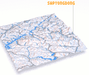 Places with similar names to Sap'yŏng-dong, Korea, North ::
Disclaimer :: Information on this page comes without warranty of any kind |
||
|
Where is Sap'yŏng-dong? Elevation and coordinates ::
Latitude (lat): 40°24'0"N Longitude (lon): 125°59'0"E
Elevation (approx.): 459m (map arrows pan, magnifying glasses zoom) |
||
|
Visiting Sap'yŏng-dong? Hotel/Accommodation ::
Book a hotel in Sap'yŏng-dong Travel Guide ::
rental cars ::
car rental offers GPS waypoint ::
download a GPX waypoint (PoI) of Sap'yŏng-dong for your GPS receiver
|
||