|
search place name
|
||
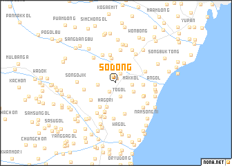
So-dong (Hamgyŏng, Korea, North)So-dong is a town in the Hamgyŏng region of Korea, North. An overview map of the region around So-dong is displayed below.
regional and 3d topo map of So-dong, Korea, North ::
Nearby towns ::
Chik-kol (0.8km north) //
Pakch'ung-nodongjagu (1.2km north) //
Chumakkŏ-ri (1.6km north) //
Simnijŏng (1.6km north) //
Saenggiryŏng-nodongjagu (1.6km south west) //
Sobakch'ung-gol (2.1km north) //
Kwangnyŏn'gol (2.2km south) //
Togol (2.2km south) //
Makkol (2.0km east) //
Chaebong-gol (2.6km north west) //
Pakha-dong (2.2km west) //
Sŏngnam-dong (3.0km north) //
Nongsa-kol (2.5km south east) //
Chumakkŏri (3.4km north east) //
Pongam-gol (4.0km north) //
Hagŏri (4.0km south) //
Hansanggol (3.3km east) //
Kolbanggol (3.3km east) //
Osang-ni (4.6km north) //
Ŏjaeng-gol (4.3km south west) //
Tojang-gol (4.1km south west) //
Pukchakkol (4.0km south east) //
Namjakkol (4.0km south east) //
Nongsagol (4.0km south east) //
Che-ch'on (4.8km south) //
Hyŏndŏng-mal (4.0km south east) //
Chuŭl-li (4.9km south) //
Sŭngam-nodongjagu (4.0km north east) //
Habongbu (4.9km north) //
[all distances 'as the bird flies' and approximate] 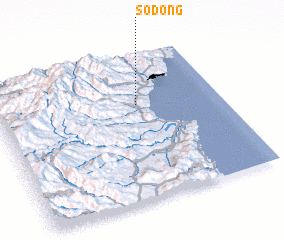 Places with similar names to So-dong, Korea, North ::
Disclaimer :: Information on this page comes without warranty of any kind |
||
|
Where is So-dong? Elevation and coordinates ::
Latitude (lat): 41°39'10"N Longitude (lon): 129°37'36"E
Elevation (approx.): 42m (map arrows pan, magnifying glasses zoom) |
||
|
Visiting So-dong? Hotel/Accommodation ::
Book a hotel in So-dong Travel Guide ::
rental cars ::
car rental offers GPS waypoint ::
download a GPX waypoint (PoI) of So-dong for your GPS receiver
|
||