|
search place name
|
||
Sŏman (Hamgyŏng, Korea, North)Sŏman is a town in the Hamgyŏng region of Korea, North. An overview map of the region around Sŏman is displayed below.
regional and 3d topo map of Sŏman, Korea, North ::
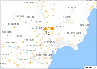
Nearby towns ::
Chajak-tong (1.2km north east) //
Wŏlp'o-ri (1.6km south) //
Namsŏk (1.2km west) //
Susŏng-dong (1.7km north west) //
Ch'up'yŏng-dong (2.0km south east) //
Chikha-ri (1.9km north east) //
Tŏktan (2.0km south west) //
To-gol (2.6km north east) //
In'gol-tong (2.5km east) //
Tut'ŏul-gol (2.6km west) //
Yugwan-dong (3.4km north) //
Pisŏk-kol (3.6km north) //
Ch'ŏngjin (3.2km south east) //
Hoeam-dong (3.2km south west) //
Ch'ŏngam-dong (3.0km east) //
Ch'angp'yŏng-dong (3.0km east) //
Sunam-dong (4.0km south) //
Minari-gol (3.2km west) //
Ch'ŏngnam-dong (3.4km south east) //
Panjuk-tong (3.4km south east) //
Makson-dong (3.3km west) //
Yongho-ri (4.5km south) //
Yonghyang-dong (4.2km south west) //
Oyŏng-dong (4.7km north) //
Songgong-ni (4.1km north west) //
Kŭndong-ni (3.6km west) //
Kangdŏgi (4.7km south) //
Changsaeng-dong (4.5km north east) //
Ch'ang-gol (4.2km north east) //
[all distances 'as the bird flies' and approximate] 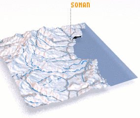 Places with similar names to Sŏman, Korea, North ::
Disclaimer :: Information on this page comes without warranty of any kind |
||
|
Where is Sŏman? Elevation and coordinates ::
Latitude (lat): 41°48'54"N Longitude (lon): 129°44'51"E
Elevation (approx.): 10m (map arrows pan, magnifying glasses zoom) |
||
|
Visiting Sŏman? Hotel/Accommodation ::
Book a hotel in Sŏman Travel Guide ::
rental cars ::
car rental offers GPS waypoint ::
download a GPX waypoint (PoI) of Sŏman for your GPS receiver
|
||