|
search place name
|
||
Song-dong (Hamgyŏng, Korea, North)Song-dong is a town in the Hamgyŏng region of Korea, North. An overview map of the region around Song-dong is displayed below.
regional and 3d topo map of Song-dong, Korea, North ::
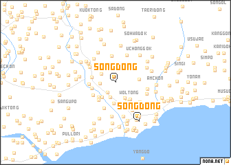
Nearby towns ::
Songdong-ni (1.9km south west) //
Kajang-dong (1.9km west) //
Chodang-dong (2.5km south) //
Sa-dong (2.2km north west) //
Pang-dong (2.8km south east) //
Hŏch'on-dong (3.1km north) //
Ch'ae-dong (2.8km south west) //
Wanjŏn-dong (3.4km south) //
Pukkan-dong (3.3km north east) //
Tunjŏn-dong (3.3km south east) //
Chaga-ri (3.1km south west) //
Wŏl-tong (3.3km south east) //
Nŭngsan-dong (2.9km east) //
Susŏ-dong (3.0km west) //
Wayŏn-dong (3.0km west) //
Chaeyŏng-dong (3.5km south west) //
Namsan-dong (4.0km south) //
Hwadae-ŭp (4.0km south) //
Cho-dong (3.5km south west) //
Pomak-tong (3.2km west) //
Yoso-dong (4.3km north) //
Chimyŏng-dong (4.4km south) //
Mundal-tong (4.6km north) //
Haryŏn-dong (4.0km north west) //
Kongsim (4.3km south east) //
Nongp'yŏng-dong (4.6km north west) //
Sŏnggu-dong (5.0km south east) //
Changp'o (4.1km east) //
Sangnyŏn-dong (4.5km north west) //
[all distances 'as the bird flies' and approximate] 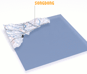 Places with similar names to Song-dong, Korea, North ::
// Sangadaung (MM)
// Sa-ngawdung (MM)
// Sina Gahtawng (MM)
// Sungai Tinggi (MY)
// Sungai Udang (MY)
// Singatanga (BF)
// Songotongo (GT)
// Sungaitengah (ID)
// Sungaiudang (ID)
// Sangatanga (GA)
Disclaimer :: Information on this page comes without warranty of any kind |
||
|
Where is Song-dong? Elevation and coordinates ::
Latitude (lat): 40°52'16"N Longitude (lon): 129°29'9"E
Elevation (approx.): 75m (map arrows pan, magnifying glasses zoom) |
||
|
Visiting Song-dong? Hotel/Accommodation ::
Book a hotel in Song-dong Travel Guide ::
rental cars ::
car rental offers GPS waypoint ::
download a GPX waypoint (PoI) of Song-dong for your GPS receiver
|
||