|
search place name
|
||
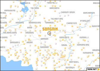
Songnim (Korea, North)Songnim is a town in Korea, North. An overview map of the region around Songnim is displayed below.
regional and 3d topo map of Songnim, Korea, North ::
Songnim airports ::
The nearest airport is FNJ - Pyongyang Intl, located 89.0 km south east of Songnim.
Nearby towns ::
Songhyŏl-li (1.0km east) //
Urari-maŭl (1.4km east) //
Tongch'ŏn (1.4km west) //
Kama-gol (1.9km north) //
Yangji-gol (1.9km north east) //
Tŏk-kol (2.2km south east) //
Samso-ri (2.8km south west) //
Tongp'abal (3.7km south) //
Tohwa-gol (3.7km north) //
Paekhak-tong (2.8km west) //
Sujin-gol (3.2km north east) //
Wŏlch'ŏl-li (3.0km north west) //
Sanggan-dong (3.5km south east) //
Hyoja-ri (3.8km south west) //
Sŏnch'ŏn-ŭp (3.2km west) //
Hyŏn-gol (3.4km south east) //
Nogongsan (4.0km south) //
Ilbongdong-Tae-dong (3.4km north east) //
Ihyŏn (4.0km south) //
Songga-gol (3.4km north east) //
Samma-gol (3.4km north east) //
Sŏlmae-dong (4.0km north) //
Yongsu-dong (3.4km north west) //
Su-dong (3.4km north west) //
Tokchangsan (4.4km south) //
In'gong-ni (3.6km south east) //
Ilso-ri (3.9km south west) //
K'ŭn-maŭl (4.0km south east) //
Isŏng-dong (4.7km north west) //
[all distances 'as the bird flies' and approximate]  Places with similar names to Songnim, Korea, North ::
// Sengnam (MM)
// Zouingonmè (BJ)
// Sanggonemi (KP)
// Sangnim (KP)
// Sangnim (KP)
// Sŏngnam (KP)
// Sŏngnam (KP)
// Songnim (KP)
// Saengnim (KR)
// Sangnam (KR)
Disclaimer :: Information on this page comes without warranty of any kind |
||
|
Where is Songnim? Elevation and coordinates ::
Latitude (lat): 39°48'0"N Longitude (lon): 124°57'0"E
Elevation (approx.): 124m (map arrows pan, magnifying glasses zoom) |
||
|
Visiting Songnim? Hotel/Accommodation ::
Book a hotel in Songnim Travel Guide ::
rental cars ::
car rental offers GPS waypoint ::
download a GPX waypoint (PoI) of Songnim for your GPS receiver
|
||