|
search place name
|
||
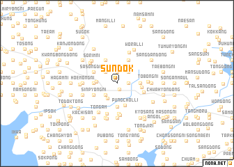
Sundŏk (Korea, North)Sundŏk is a town in Korea, North. An overview map of the region around Sundŏk is displayed below.
regional and 3d topo map of Sundŏk, Korea, North ::
Sundŏk airports ::
The nearest airport is FNJ - Pyongyang Intl, located 109.7 km south east of Sundŏk.
Nearby towns ::
Tongnim-ŭp (1.0km south) //
Yakpong-ni (1.9km north) //
Sŏnam (1.9km north) //
Nogam (1.9km north) //
Tongch'ŏn-dong (1.4km east) //
Chambong-ni (2.1km north) //
Ch'odang-ni (2.4km north) //
Yonghŭng-ni (2.3km north east) //
Chamdu-ri (2.3km north west) //
Ch'ungsan-ni (2.3km south west) //
Kinbal (2.3km south west) //
Hoedŏk (2.3km south west) //
Yongdu (2.3km south west) //
Yongsal-li (2.6km south west) //
Yŏnsal-li (2.5km west) //
Sŏwŏn-ni (2.8km east) //
Tongsan-ni (2.8km west) //
Ch'aeryŏn-ni (2.8km west) //
Ponggong-ni (3.7km south) //
Songhyŏn (3.7km south) //
P'ungch'ŏl-li (3.7km south) //
Obong-nodongjagu (3.1km east) //
Sasong-dong (3.4km north west) //
Ok-tong (4.0km north) //
Wŏrunch'ŏn (4.0km north) //
Sinp'yŏng-ni (3.4km south west) //
Chŏndobong (3.6km south east) //
Kŭmsŏng (4.8km south) //
Tobong-ni (3.8km east) //
[all distances 'as the bird flies' and approximate]  Places with similar names to Sundŏk, Korea, North ::
Disclaimer :: Information on this page comes without warranty of any kind |
||
|
Where is Sundŏk? Elevation and coordinates ::
Latitude (lat): 39°52'0"N Longitude (lon): 124°42'0"E
Elevation (approx.): 39m (map arrows pan, magnifying glasses zoom) |
||
|
Visiting Sundŏk? Hotel/Accommodation ::
Book a hotel in Sundŏk Travel Guide ::
rental cars ::
car rental offers GPS waypoint ::
download a GPX waypoint (PoI) of Sundŏk for your GPS receiver
|
||