|
search place name
|
||
Suryangdŏk (Hamgyŏng, Korea, North)Suryangdŏk is a town in the Hamgyŏng region of Korea, North. An overview map of the region around Suryangdŏk is displayed below.
regional and 3d topo map of Suryangdŏk, Korea, North ::
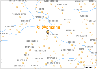
Nearby towns ::
Taegarim (0.6km south west) //
Sogarim (1.9km south) //
Sedongp'o (2.4km south west) //
Ch'ŏngp'o (2.2km south east) //
Taep'o (2.9km north) //
Kŏmunjik (3.7km north) //
Pukhoe-dong (3.4km south east) //
Nŭlch'angdŏk (3.6km north east) //
Taenamsŏk-kol (4.5km south) //
Chingmip'o (4.5km north) //
Sŭngam (3.6km west) //
Sonamsŏk-tong (5.2km south) //
Ch'aam-dong (5.5km north) //
Hoe-dong (5.4km south east) //
Sinp'unghyang (5.7km south west) //
Sinun-dong (5.3km north east) //
Kwangdŏk-tong (6.5km north) //
Taegŏnp'o (6.2km north west) //
Changnim-ni (6.7km south) //
Taedolsu (5.3km east) //
Wŏlmae-dong (6.0km south west) //
Tŭngnŭm-ni (7.7km south) //
Hanjinnugae (7.8km south) //
Hapsu (8.2km north) //
Yu-dong (8.2km south) //
Saedolsu (6.5km east) //
Puk-kol (7.5km north east) //
Namsa (9.0km north) //
Puk-kol (7.6km north east) //
[all distances 'as the bird flies' and approximate] 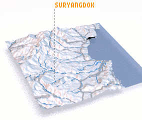 Places with similar names to Suryangdŏk, Korea, North :: Disclaimer :: Information on this page comes without warranty of any kind |
||
|
Where is Suryangdŏk? Elevation and coordinates ::
Latitude (lat): 41°23'30"N Longitude (lon): 129°15'30"E
Elevation (approx.): 759m (map arrows pan, magnifying glasses zoom) |
||
|
Visiting Suryangdŏk? Hotel/Accommodation ::
Book a hotel in Suryangdŏk Travel Guide ::
rental cars ::
car rental offers GPS waypoint ::
download a GPX waypoint (PoI) of Suryangdŏk for your GPS receiver
|
||