|
search place name
|
||
Tŏgam-ni (Korea, North)Tŏgam-ni is a town in Korea, North. An overview map of the region around Tŏgam-ni is displayed below.
regional and 3d topo map of Tŏgam-ni, Korea, North ::

Tŏgam-ni airports ::
The nearest airport is FNJ - Pyongyang Intl, located 73.1 km north west of Tŏgam-ni.
Other airports nearby include GMP - Seoul Gimpo (154.3 km south), SSN - Seoul East Seoul Ab (174.3 km south), OSN - Osan Ab (209.7 km south), Nearby towns ::
Nŭngp'a (0.0km north) //
Oedae-dong (2.7km north west) //
Nojŏn-dong (2.9km south west) //
Taegong-ni (3.7km north) //
Sŏktal-li (5.4km south east) //
Kokch'ang (5.7km north) //
Hwasim-ni (4.7km north east) //
Sŏkhyŏl-li (6.4km south) //
Hyangdan-ni (5.7km north west) //
Holtong-nodongjagu (6.8km south) //
Imgang-ni (5.8km east) //
Yugang-ni (6.9km south east) //
Saengdongga (8.3km south west) //
Saenggŭm-ni (9.4km south west) //
Kubin-ni (10.5km north west) //
[all distances 'as the bird flies' and approximate] 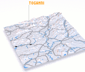 Places with similar names to Tŏgam-ni, Korea, North ::
Disclaimer :: Information on this page comes without warranty of any kind |
||
|
Where is Tŏgam-ni? Elevation and coordinates ::
Latitude (lat): 38°55'0"N Longitude (lon): 126°25'0"E
Elevation (approx.): 290m (map arrows pan, magnifying glasses zoom) |
||
|
Visiting Tŏgam-ni? Hotel/Accommodation ::
Book a hotel in Tŏgam-ni Travel Guide ::
rental cars ::
car rental offers GPS waypoint ::
download a GPX waypoint (PoI) of Tŏgam-ni for your GPS receiver
|
||