|
search place name
|
||
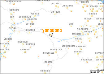
Yong-dong (Kangwŏn, Korea, North)Yong-dong is a town in the Kangwŏn region of Korea, North. An overview map of the region around Yong-dong is displayed below.
regional and 3d topo map of Yong-dong, Korea, North ::
Yong-dong airports ::
The nearest airport is FNJ - Pyongyang Intl, located 138.0 km west of Yong-dong.
Other airports nearby include SHO - Sokch'o Sokcho (155.6 km south east), GMP - Seoul Gimpo (172.1 km south), SSN - Seoul East Seoul Ab (180.2 km south), KAG - Kangnung Gangneung (207.3 km south east), Nearby towns ::
Yŏngjŏ-ri (3.1km north west) //
Taegak-tong (5.5km south) //
Sot'ong-gol (6.7km south) //
Wŏlmyŏnggok (6.3km south east) //
San-ni (6.7km north east) //
Kŭmdong-ni (6.3km west) //
Samt'ae-ri (8.2km north) //
P'andŏng-ni (8.0km south west) //
Ch'a-dong (7.0km south west) //
Posŏng-ni (6.8km east) //
Ŏktong-ni (7.2km north west) //
Pokhoe-ri (7.8km north west) //
Masing-ni (8.9km north west) //
[all distances 'as the bird flies' and approximate]  Places with similar names to Yong-dong, Korea, North ::
// Hyŏn'ga-dong (KP)
// Hyŏng-dong (KP)
// Yang-dong (KP)
// Yang-dong (KP)
// Yang-dong (KP)
// Yang-dong (KP)
// Yangga-dong (KP)
// Yangŏ-dong (KP)
// Yangŏ-dong (KP)
// Yongdang (KP)
Disclaimer :: Information on this page comes without warranty of any kind |
||
|
Where is Yong-dong? Elevation and coordinates ::
Latitude (lat): 39°3'55"N Longitude (lon): 127°15'13"E
Elevation (approx.): 706m (map arrows pan, magnifying glasses zoom) |
||
|
Visiting Yong-dong? Hotel/Accommodation ::
Book a hotel in Yong-dong Travel Guide ::
rental cars ::
car rental offers GPS waypoint ::
download a GPX waypoint (PoI) of Yong-dong for your GPS receiver
|
||