|
search place name
|
||
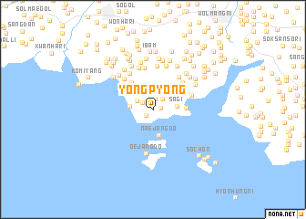
Yŏngp'yŏng (P'yŏngan, Korea, North)Yŏngp'yŏng is a town in the P'yŏngan region of Korea, North. An overview map of the region around Yŏngp'yŏng is displayed below.
regional and 3d topo map of Yŏngp'yŏng, Korea, North ::
Yŏngp'yŏng airports ::
The nearest airport is FNJ - Pyongyang Intl, located 60.2 km south east of Yŏngp'yŏng.
Nearby towns ::
Hanyang (0.7km east) //
Ch'angjŏn (1.0km north) //
Changjae-gol (1.0km south west) //
Naesorok (1.4km north) //
Yangji (1.3km north west) //
An'gok (1.6km north east) //
An-dong (1.8km north west) //
Oesorok (2.1km north) //
Ch'ŏndae-ri (2.5km north west) //
Sŏnmi (2.3km west) //
Sagi (2.3km east) //
Naejangdo (3.2km south) //
Sŏng-dong (3.2km north west) //
Saho-dong (3.2km east) //
Haeyang (3.8km north west) //
Maemisŏm (3.9km north east) //
Posal-li (4.3km north east) //
Kajang-dong (5.0km north) //
Hwanggyŏng (4.7km north east) //
Yongdang (4.6km north west) //
Sang-ni (5.1km north) //
Wŏl-li (4.9km north west) //
Tonggang (5.3km north) //
Oejangdo (5.3km south) //
Su-dong (5.4km north) //
Yongsŏng (5.2km north west) //
Wŏnp'o-ri (5.8km north) //
Nae-dong (5.0km north east) //
Samdae (5.7km north) //
[all distances 'as the bird flies' and approximate] 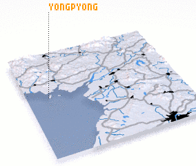 Places with similar names to Yŏngp'yŏng, Korea, North ::
// Yongp'yŏng (KP)
// Yangp'yŏng (KR)
// Yŏngp'yŏng (KR)
// Yŏngp'yŏng (KR)
// Yŏngp'yŏng (KR)
// Yongup'yŏng (KP)
Disclaimer :: Information on this page comes without warranty of any kind |
||
|
Where is Yŏngp'yŏng? Elevation and coordinates ::
Latitude (lat): 39°34'49"N Longitude (lon): 125°8'34"E
Elevation (approx.): 18m (map arrows pan, magnifying glasses zoom) |
||
|
Visiting Yŏngp'yŏng? Hotel/Accommodation ::
Book a hotel in Yŏngp'yŏng Travel Guide ::
rental cars ::
car rental offers GPS waypoint ::
download a GPX waypoint (PoI) of Yŏngp'yŏng for your GPS receiver
|
||