|
search place name
|
||
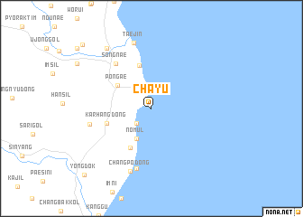
Ch'ayu (Kyŏngsang, Korea, South)Ch'ayu is a town in the Kyŏngsang region of Korea, South. An overview map of the region around Ch'ayu is displayed below.
regional and 3d topo map of Ch'ayu, Korea, South ::
Ch'ayu airports ::
The nearest airport is KPO - Pohang, located 55.0 km south of Ch'ayu.
Other airports nearby include TAE - Taegu Daegu Ab (96.6 km south west), USN - Ulsan (99.1 km south), YEC - Yechon Yecheon (99.4 km west), KAG - Kangnung Gangneung (148.0 km north), Nearby towns ::
Yŏmjang (2.3km north west) //
Yejin (2.4km south west) //
Ch'uksan-dong (2.9km north) //
Nomul (4.0km south) //
Pŏn'gae (4.5km north west) //
Sajin 2-dong (5.4km north) //
Taet'an (5.4km south west) //
Karhang-dong (4.8km south west) //
Sŏngnae (6.5km north west) //
Ch'angp'o (7.6km south) //
Hwach'ŏn (6.4km west) //
Ch'angp'o-dong (8.0km south) //
Taejin (8.3km north) //
Songch'ŏn (8.7km north west) //
Araenara-gol (10.4km north west) //
Yŏngdŏk (10.6km south west) //
[all distances 'as the bird flies' and approximate] 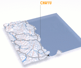 Places with similar names to Ch'ayu, Korea, South ::
Disclaimer :: Information on this page comes without warranty of any kind |
||
|
Where is Ch'ayu? Elevation and coordinates ::
Latitude (lat): 36°29'0"N Longitude (lon): 129°27'0"E
Elevation (approx.): -32768m (map arrows pan, magnifying glasses zoom) |
||
|
Visiting Ch'ayu? Hotel/Accommodation ::
Book a hotel in Ch'ayu Travel Guide ::
rental cars ::
car rental offers GPS waypoint ::
download a GPX waypoint (PoI) of Ch'ayu for your GPS receiver
|
||