|
search place name
|
||
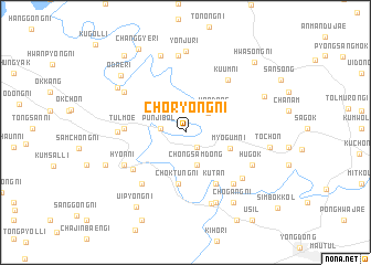
Choryŏng-ni (Ch'ungch'ŏng, Korea, South)Choryŏng-ni is a town in the Ch'ungch'ŏng region of Korea, South. An overview map of the region around Choryŏng-ni is displayed below.
regional and 3d topo map of Choryŏng-ni, Korea, South ::
Choryŏng-ni airports ::
The nearest airport is YEC - Yechon Yecheon, located 72.5 km north east of Choryŏng-ni.
Other airports nearby include TAE - Taegu Daegu Ab (98.6 km south east), KUB - Kunsan Ab (103.9 km south west), OSN - Osan Ab (106.8 km north west), SSN - Seoul East Seoul Ab (138.6 km north), Nearby towns ::
Naech'on (1.8km south east) //
Punjibŏl (2.1km west) //
Kodang-ni (2.7km north east) //
Chŏngsam-dong (3.5km south) //
Wŏndang (3.3km north east) //
Myogŭm-ni (4.0km south east) //
Chŏktŭng-ni (5.2km south) //
Kut'an (5.7km south east) //
Tŭlmoe (5.0km west) //
Iwŏl-li (5.7km south west) //
Hyŏnnam (6.3km south west) //
Kuŭm-ni (6.3km north east) //
P'yŏngsal-li (5.5km west) //
Hyŏn-ni (6.0km south west) //
Simch'ŏn (6.5km south east) //
Simch'ŏl-li (6.6km south east) //
Chisŏng-ni (6.5km north west) //
Hugok (6.4km south east) //
Kodang-ni (7.5km south) //
Okkil-tong (7.5km south) //
Kosŏng (7.8km north) //
Yŏnju-ri (8.2km north) //
P'isil (8.0km north) //
Sŏkt'al-li (7.2km north west) //
Ch'ogang-ni (8.1km south east) //
Odae-ri (7.8km north west) //
Toch'ŏn (7.1km east) //
Chinp'yŏng (7.3km south west) //
Changsu-ri (7.4km north east) //
[all distances 'as the bird flies' and approximate]  Places with similar names to Choryŏng-ni, Korea, South ::
// Ch'aeryŏng-ni (KP)
// Cheryŏng-ni (KP)
// Choryŏng-ni (KP)
// Charyong-ni (KR)
// Choryŏng-ni (KR)
// Choryŏng-ni (KR)
// Choryŏng-ni (KR)
// Churyŏng-ni (KR)
// Ch'aryung-ni (KP)
// Ch'oeryŏng-ni (KP)
Disclaimer :: Information on this page comes without warranty of any kind |
||
|
Where is Choryŏng-ni? Elevation and coordinates ::
Latitude (lat): 36°16'48"N Longitude (lon): 127°40'22"E
Elevation (approx.): 105m (map arrows pan, magnifying glasses zoom) |
||
|
Visiting Choryŏng-ni? Hotel/Accommodation ::
Book a hotel in Choryŏng-ni Travel Guide ::
rental cars ::
car rental offers GPS waypoint ::
download a GPX waypoint (PoI) of Choryŏng-ni for your GPS receiver
|
||