|
search place name
|
||
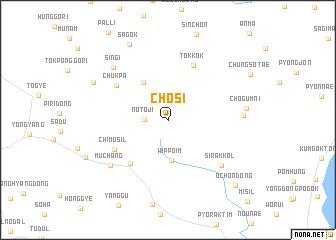
Chŏsi (Kyŏngsang, Korea, South)Chŏsi is a town in the Kyŏngsang region of Korea, South. An overview map of the region around Chŏsi is displayed below.
regional and 3d topo map of Chŏsi, Korea, South ::
Chŏsi airports ::
The nearest airport is KPO - Pohang, located 78.0 km south of Chŏsi.
Other airports nearby include YEC - Yechon Yecheon (80.9 km west), TAE - Taegu Daegu Ab (102.3 km south west), USN - Ulsan (120.7 km south), KAG - Kangnung Gangneung (122.5 km north), Nearby towns ::
Nŏt'ŏji (2.1km west) //
Wippŏim (4.5km south) //
Changp'a (4.8km north west) //
Changp'ungwŏn (5.9km south west) //
Tokkok (6.5km north) //
Chimusil (5.8km south west) //
Chukp'a (6.0km north west) //
Sirak-kol (6.9km south east) //
Much'ang (7.2km south west) //
Sangjogŭm (6.8km east) //
Sin'gi (7.6km north west) //
Chogŭm-ni (7.1km east) //
Songjŏng (7.9km north west) //
Sagok (9.1km north) //
Och'on-dong (9.5km south east) //
[all distances 'as the bird flies' and approximate] 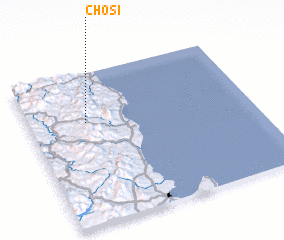 Places with similar names to Chŏsi, Korea, South ::
Disclaimer :: Information on this page comes without warranty of any kind |
||
|
Where is Chŏsi? Elevation and coordinates ::
Latitude (lat): 36°40'43"N Longitude (lon): 129°15'28"E
Elevation (approx.): 555m (map arrows pan, magnifying glasses zoom) |
||
|
Visiting Chŏsi? Hotel/Accommodation ::
Book a hotel in Chŏsi Travel Guide ::
rental cars ::
car rental offers GPS waypoint ::
download a GPX waypoint (PoI) of Chŏsi for your GPS receiver
|
||