|
search place name
|
||
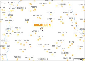
Hagaegŭm (Kyŏngsang, Korea, South)Hagaegŭm is a town in the Kyŏngsang region of Korea, South. An overview map of the region around Hagaegŭm is displayed below.
regional and 3d topo map of Hagaegŭm, Korea, South ::
Hagaegŭm airports ::
The nearest airport is TAE - Taegu Daegu Ab, located 54.0 km east of Hagaegŭm.
Other airports nearby include YEC - Yechon Yecheon (93.7 km north), PUS - Kimhae Gimhae Intl (106.2 km south east), RSU - Yeosu (115.9 km south), USN - Ulsan (118.8 km east), Nearby towns ::
Yongam (2.7km south west) //
Ch'iil-li (3.6km south) //
Majang-dong (3.7km south) //
Ch'omak-tong (4.4km south) //
Songjŏng (4.5km south west) //
Magosil (5.4km north) //
Kyo-dong (5.1km north east) //
Changjŏn-dong (5.7km north) //
Sin'gye-ri (5.3km north east) //
Ch'ŏngch'ŏni (6.0km north) //
Sŏkkye-dong (6.9km south) //
Sudo (6.6km north west) //
Sansŏng (7.6km north) //
Kuwŏn-dong (7.5km south east) //
Ŏin (8.3km south west) //
Kongsu (7.8km south west) //
Masu (7.6km north east) //
Komsil (7.9km north east) //
Chŏm-gol (8.5km south east) //
Sach'ol-li (9.1km south east) //
Sangbŏmnim (8.8km north east) //
Pyŏngch'on (9.7km north west) //
Uhye-ri (9.1km south west) //
[all distances 'as the bird flies' and approximate] 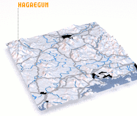 Places with similar names to Hagaegŭm, Korea, South :: Disclaimer :: Information on this page comes without warranty of any kind |
||
|
Where is Hagaegŭm? Elevation and coordinates ::
Latitude (lat): 35°49'11"N Longitude (lon): 128°4'5"E
Elevation (approx.): 775m (map arrows pan, magnifying glasses zoom) |
||
|
Visiting Hagaegŭm? Hotel/Accommodation ::
Book a hotel in Hagaegŭm Travel Guide ::
rental cars ::
car rental offers GPS waypoint ::
download a GPX waypoint (PoI) of Hagaegŭm for your GPS receiver
|
||