|
search place name
|
||
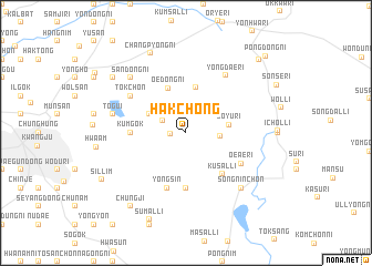
Hakchŏng (Korea, South)Hakchŏng is a town in Korea, South. An overview map of the region around Hakchŏng is displayed below.
regional and 3d topo map of Hakchŏng, Korea, South ::
Hakchŏng airports ::
The nearest airport is KWJ - Kwangju Gwangju, located 22.4 km west of Hakchŏng.
Other airports nearby include RSU - Yeosu (63.0 km south east), KUB - Kunsan Ab (90.8 km north west), TAE - Taegu Daegu Ab (166.7 km north east), PUS - Kimhae Gimhae Intl (172.0 km east), Nearby towns ::
Chŏnggong-ni (1.3km west) //
Yŏnch'ŏl-li (2.3km north west) //
Ong-ni (2.8km east) //
Chisil (3.6km north west) //
Sŏyu-ri (3.7km east) //
Ipsŏng-ni (4.7km north) //
Oedong-ni (4.7km north) //
Kŭmgok (4.5km west) //
Kusal-li (5.1km south east) //
Powŏl-li (5.6km south) //
Yŏngsin (5.8km south) //
Oeae-ri (5.5km south east) //
Tŏkch'on (5.9km north west) //
Yongdae-ri (6.6km north east) //
Tŏgŭi (6.3km west) //
Sandŏng-ni (7.2km north west) //
Sŏngnin-ch'on (7.2km south east) //
Ch'angp'yŏng-ni (8.5km north) //
Chungji (8.7km south west) //
Kyoch'on (8.2km north west) //
Sumal-li (9.2km south) //
Sillim (8.4km south west) //
Haman (9.6km north east) //
Pongdong-ni (10.2km north east) //
[all distances 'as the bird flies' and approximate] 
Disclaimer :: Information on this page comes without warranty of any kind |
||
|
Where is Hakchŏng? Elevation and coordinates ::
Latitude (lat): 35°10'0"N Longitude (lon): 127°3'0"E
Elevation (approx.): 346m (map arrows pan, magnifying glasses zoom) |
||
|
Visiting Hakchŏng? Hotel/Accommodation ::
Book a hotel in Hakchŏng Travel Guide ::
rental cars ::
car rental offers GPS waypoint ::
download a GPX waypoint (PoI) of Hakchŏng for your GPS receiver
|
||