|
search place name
|
||
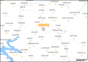
Hapsu (Kyŏngsang, Korea, South)Hapsu is a town in the Kyŏngsang region of Korea, South. An overview map of the region around Hapsu is displayed below.
regional and 3d topo map of Hapsu, Korea, South ::
Hapsu airports ::
The nearest airport is YEC - Yechon Yecheon, located 57.0 km west of Hapsu.
Other airports nearby include KPO - Pohang (94.5 km south east), TAE - Taegu Daegu Ab (100.1 km south), KAG - Kangnung Gangneung (110.4 km north), USN - Ulsan (133.7 km south), Nearby towns ::
Irŭmsil (3.4km north west) //
In'gŭm (3.4km north west) //
Omi-gol (3.7km south) //
Malgok (3.5km south west) //
Tugye-gol (4.6km north) //
Maeng-ch'on (4.8km east) //
Kurŏngma (5.5km north east) //
Tujŏn (5.1km east) //
Hyŏn-dong (6.5km north) //
Chungsin-ch'on (6.0km north east) //
Kaemŏ-ri (6.0km south east) //
Wŏnŭm (6.3km south west) //
Pulmi-gol (7.4km south) //
Sŏnghwang-ni (7.5km south west) //
Myo-gol (7.9km north) //
Karŏjŏm (8.5km south) //
Purisil (8.5km north) //
Kosa (7.1km east) //
Nŏraebau (8.9km south east) //
Tok-kol (8.8km south west) //
[all distances 'as the bird flies' and approximate]  Places with similar names to Hapsu, Korea, South ::
Disclaimer :: Information on this page comes without warranty of any kind |
||
|
Where is Hapsu? Elevation and coordinates ::
Latitude (lat): 36°45'33"N Longitude (lon): 128°58'24"E
Elevation (approx.): 434m (map arrows pan, magnifying glasses zoom) |
||
|
Visiting Hapsu? Hotel/Accommodation ::
Book a hotel in Hapsu Travel Guide ::
rental cars ::
car rental offers GPS waypoint ::
download a GPX waypoint (PoI) of Hapsu for your GPS receiver
|
||