|
search place name
|
||
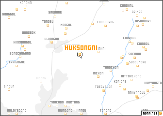
Hŭksŏng-ni (Kyŏnggi, Korea, South)Hŭksŏng-ni is a town in the Kyŏnggi region of Korea, South. An overview map of the region around Hŭksŏng-ni is displayed below.
regional and 3d topo map of Hŭksŏng-ni, Korea, South ::
Hŭksŏng-ni airports ::
The nearest airport is SSN - Seoul East Seoul Ab, located 30.1 km south of Hŭksŏng-ni.
Other airports nearby include GMP - Seoul Gimpo (32.5 km south west), OSN - Osan Ab (69.8 km south), SHO - Sokch'o Sokcho (140.0 km east), KAG - Kangnung Gangneung (162.6 km east), Nearby towns ::
Pondunya (2.5km north west) //
Yongam-ni (3.3km north east) //
Im-ch'on (5.3km south east) //
Majŏn (6.3km north west) //
Tong-ch'on (6.2km south east) //
Moo-gol (7.3km north) //
Ŭijŏngbu (6.4km north west) //
Muran (8.0km north) //
T'oegyewŏn (8.6km south east) //
Tongch'ang (8.6km north east) //
Tongbu (9.6km north west) //
[all distances 'as the bird flies' and approximate]  Places with similar names to Hŭksŏng-ni, Korea, South ::
// Hagzinken (DE)
// Haksŏng-ni (KP)
// Haksong-ni (KP)
// Haksong-ni (KP)
// Haksong-ni (KP)
// Haksŏng-ni (KR)
// Haksŏng-ni (KR)
// Haksŏng-ni (KR)
// Haksong-ni (KR)
// Hŭksŏng-ni (KR)
Disclaimer :: Information on this page comes without warranty of any kind |
||
|
Where is Hŭksŏng-ni? Elevation and coordinates ::
Latitude (lat): 37°43'0"N Longitude (lon): 127°6'0"E
Elevation (approx.): 81m (map arrows pan, magnifying glasses zoom) |
||
|
Visiting Hŭksŏng-ni? Hotel/Accommodation ::
Book a hotel in Hŭksŏng-ni Travel Guide ::
rental cars ::
car rental offers GPS waypoint ::
download a GPX waypoint (PoI) of Hŭksŏng-ni for your GPS receiver
|
||