|
search place name
|
||
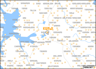
Kŭmji (Chŏlla, Korea, South)Kŭmji is a town in the Chŏlla region of Korea, South. An overview map of the region around Kŭmji is displayed below.
regional and 3d topo map of Kŭmji, Korea, South ::
Kŭmji airports ::
The nearest airport is KWJ - Kwangju Gwangju, located 36.2 km north of Kŭmji.
Other airports nearby include RSU - Yeosu (85.4 km east), KUB - Kunsan Ab (120.8 km north), CJU - Cheju Jeju Intl (145.9 km south), TAE - Taegu Daegu Ab (215.7 km north east), Nearby towns ::
Songp'yŏng-ni (1.5km south west) //
Mogu-dong (1.9km north) //
Sin'gi (1.5km west) //
Manghojŏng (1.9km south) //
Tŏkchil-li (1.5km east) //
Ch'ŏngnim (2.4km north east) //
P'yŏngjang (2.4km south west) //
Osan (2.4km south west) //
Yŏngam (2.5km south east) //
Nogam (3.7km south) //
Yŏnghŭng (3.0km east) //
Ippi-dong (3.8km north) //
Kujŏng (3.6km north west) //
Torich'on (3.6km south west) //
Sindŏkchŏng (3.6km south west) //
Suhyŏn (4.0km north) //
Ho-dong (4.0km south) //
Un'gok (3.6km north east) //
Taesil-li (3.6km south east) //
Sinbok-ch'on (3.6km south east) //
Haech'ang-ni (3.5km west) //
Unam-ni (3.8km north east) //
Top'o-ri (3.8km west) //
Wŏram-ni (4.6km south west) //
Kuhang-ni (4.5km north west) //
Wanhwa (4.9km west) //
Kwangam (5.8km north) //
Saet'ŏ (4.9km east) //
Haenggun-dong (5.8km north) //
[all distances 'as the bird flies' and approximate]  Places with similar names to Kŭmji, Korea, South ::
Disclaimer :: Information on this page comes without warranty of any kind |
||
|
Where is Kŭmji? Elevation and coordinates ::
Latitude (lat): 34°49'0"N Longitude (lon): 126°41'0"E
Elevation (approx.): 7m (map arrows pan, magnifying glasses zoom) |
||
|
Visiting Kŭmji? Hotel/Accommodation ::
Book a hotel in Kŭmji Travel Guide ::
rental cars ::
car rental offers GPS waypoint ::
download a GPX waypoint (PoI) of Kŭmji for your GPS receiver
|
||