|
search place name
|
||
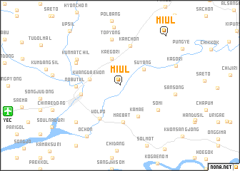
Miul (Kyŏngsang, Korea, South)Miul is a town in the Kyŏngsang region of Korea, South. An overview map of the region around Miul is displayed below.
regional and 3d topo map of Miul, Korea, South ::
Miul airports ::
The nearest airport is YEC - Yechon Yecheon, located 14.6 km west of Miul.
Other airports nearby include TAE - Taegu Daegu Ab (86.9 km south), KPO - Pohang (111.2 km south east), KAG - Kangnung Gangneung (126.4 km north), OSN - Osan Ab (140.2 km west), Nearby towns ::
Kaegŏ-ri (4.4km north) //
Suyang (3.9km north east) //
Kwangdaewŏn (3.9km west) //
Kamae (5.4km south east) //
Maebat (5.8km south) //
Wŏlp'o (5.7km south west) //
Yech'ŏn (5.1km west) //
Kamch'ŏn (6.3km north) //
Nabutŭl (5.5km west) //
Sŏmi (6.2km south east) //
Top'yŏng (7.3km north) //
K'ŭnmassil (6.6km north west) //
K'ŭnmatchil (6.8km north west) //
Sansŏng (7.1km east) //
Nae-dong (8.0km south west) //
Kagŏri (7.7km north east) //
Och'ŏn (9.0km south west) //
Miul (9.6km north east) //
Ŭpsil (10.6km north west) //
[all distances 'as the bird flies' and approximate] 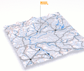 Places with similar names to Miul, Korea, South ::
Disclaimer :: Information on this page comes without warranty of any kind |
||
|
Where is Miul? Elevation and coordinates ::
Latitude (lat): 36°40'6"N Longitude (lon): 128°30'43"E
Elevation (approx.): 148m (map arrows pan, magnifying glasses zoom) |
||
|
Visiting Miul? Hotel/Accommodation ::
Book a hotel in Miul Travel Guide ::
rental cars ::
car rental offers GPS waypoint ::
download a GPX waypoint (PoI) of Miul for your GPS receiver
|
||