|
search place name
|
||
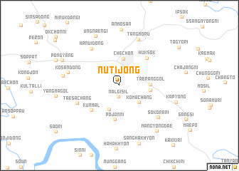
Nŭt'ijŏng (Ch'ungch'ŏng, Korea, South)Nŭt'ijŏng is a town in the Ch'ungch'ŏng region of Korea, South. An overview map of the region around Nŭt'ijŏng is displayed below.
regional and 3d topo map of Nŭt'ijŏng, Korea, South ::
Nŭt'ijŏng airports ::
The nearest airport is YEC - Yechon Yecheon, located 53.5 km south of Nŭt'ijŏng.
Other airports nearby include KAG - Kangnung Gangneung (97.7 km north east), SSN - Seoul East Seoul Ab (104.2 km west), OSN - Osan Ab (104.5 km west), SHO - Sokch'o Sokcho (121.0 km north), Nearby towns ::
Nalgisil (1.8km south) //
Handusil (4.0km south) //
Komach'ang (3.7km south east) //
Chech'ŏn (4.2km north) //
Taerang-gol (3.9km east) //
Nŭribŏn (4.0km east) //
P'ojŏn-ni (5.4km south) //
K'ŭn-mal (5.2km south west) //
Hŭksŏk (5.5km north east) //
Taesach'ang (5.9km south west) //
Hanŭi-dong (6.7km north west) //
Tangmoru (7.6km north) //
Sok'orani (7.0km south east) //
Kosan-dong (6.7km west) //
Ungnaengi (8.2km north) //
Anmosan (8.7km north) //
Tojang-gol (7.2km west) //
Kap'yŏng (7.6km east) //
Man'gyŏngdae (8.6km south east) //
[all distances 'as the bird flies' and approximate] 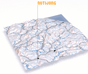 Places with similar names to Nŭt'ijŏng, Korea, South ::
Disclaimer :: Information on this page comes without warranty of any kind |
||
|
Where is Nŭt'ijŏng? Elevation and coordinates ::
Latitude (lat): 37°5'55"N Longitude (lon): 128°12'20"E
Elevation (approx.): 268m (map arrows pan, magnifying glasses zoom) |
||
|
Visiting Nŭt'ijŏng? Hotel/Accommodation ::
Book a hotel in Nŭt'ijŏng Travel Guide ::
rental cars ::
car rental offers GPS waypoint ::
download a GPX waypoint (PoI) of Nŭt'ijŏng for your GPS receiver
|
||