|
search place name
|
||
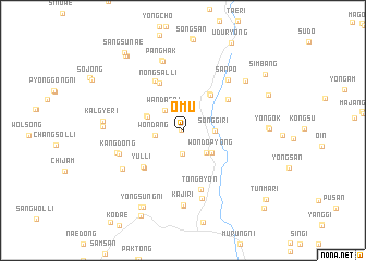
Omu (Kyŏngsang, Korea, South)Omu is a town in the Kyŏngsang region of Korea, South. An overview map of the region around Omu is displayed below.
regional and 3d topo map of Omu, Korea, South ::
Omu airports ::
The nearest airport is TAE - Taegu Daegu Ab, located 70.6 km east of Omu.
Other airports nearby include YEC - Yechon Yecheon (104.2 km north east), RSU - Yeosu (106.1 km south), PUS - Kimhae Gimhae Intl (115.4 km south east), KUB - Kunsan Ab (116.2 km west), Nearby towns ::
Naeo (0.2km north west) //
Imsil (2.3km south) //
Wandae-ri (2.6km north west) //
Wŏndang (2.3km west) //
Sŏnggi-ri (2.7km east) //
Top'yŏng-ni (3.0km south east) //
Wŏndop'yŏng (3.3km south east) //
Muwŏl (3.3km north west) //
Modong-ni (3.4km north west) //
Wonch'on (4.3km north east) //
Nohyŏl-li (4.4km north east) //
Nongsal-li (5.2km north) //
Sangyul (5.0km south west) //
Yul-li (5.0km south west) //
Tongho (4.9km north east) //
Ipsŏk (5.5km north west) //
Tongbyŏn (6.2km south) //
Kang-dong (5.8km south west) //
Sanp'o (6.4km north east) //
Changgi-ri (5.9km west) //
Mogok (7.1km south) //
Namsan (6.4km south west) //
Panghak (7.3km north) //
Hagunghang (7.4km north) //
Kaji-ri (7.6km south) //
Kaehwa (7.7km south) //
Urang-dong (7.3km north east) //
Ch'ingnae (6.7km west) //
Kalgye-ri (6.7km west) //
[all distances 'as the bird flies' and approximate]  Places with similar names to Omu, Korea, South ::
Disclaimer :: Information on this page comes without warranty of any kind |
||
|
Where is Omu? Elevation and coordinates ::
Latitude (lat): 35°46'17"N Longitude (lon): 127°53'31"E
Elevation (approx.): 268m (map arrows pan, magnifying glasses zoom) |
||
|
Visiting Omu? Hotel/Accommodation ::
Book a hotel in Omu Travel Guide ::
rental cars ::
car rental offers GPS waypoint ::
download a GPX waypoint (PoI) of Omu for your GPS receiver
|
||