|
search place name
|
||
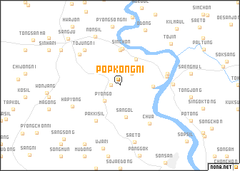
Pŏpkong-ni (Kyŏngsang, Korea, South)Pŏpkong-ni is a town in the Kyŏngsang region of Korea, South. An overview map of the region around Pŏpkong-ni is displayed below.
regional and 3d topo map of Pŏpkong-ni, Korea, South ::
Pŏpkong-ni airports ::
The nearest airport is YEC - Yechon Yecheon, located 33.1 km north of Pŏpkong-ni.
Other airports nearby include TAE - Taegu Daegu Ab (63.5 km south east), KPO - Pohang (114.1 km east), USN - Ulsan (131.2 km south east), OSN - Osan Ab (135.3 km north west), Nearby towns ::
Kwant'ŏ (1.1km west) //
Songch'ŏn (2.4km north east) //
Song-ch'on (2.4km north east) //
P'yŏngo (3.1km south west) //
Paektujŏm (4.5km north east) //
San-gol (5.1km south) //
Pong-ch'on (4.2km east) //
Araesshinch'on (5.6km north) //
Sin-ch'on (5.8km north) //
Pakkisil (6.3km south west) //
Nak-tong (6.1km east) //
Chua (7.0km south east) //
Naktong (6.3km east) //
Tojung-ni (7.1km north west) //
Uam (7.1km north west) //
Hap'yŏng (6.8km south west) //
Nakchŏng (6.7km east) //
Nonsil (8.2km north) //
Saet'ŏ (9.1km south) //
Odong (9.2km north) //
T'ojin (9.2km north east) //
Sangju (9.8km north west) //
Sangsong (11.0km south west) //
[all distances 'as the bird flies' and approximate] 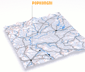 Places with similar names to Pŏpkong-ni, Korea, South ::
// Pŏpkong-ni (KR)
Disclaimer :: Information on this page comes without warranty of any kind |
||
|
Where is Pŏpkong-ni? Elevation and coordinates ::
Latitude (lat): 36°21'0"N Longitude (lon): 128°14'0"E
Elevation (approx.): 105m (map arrows pan, magnifying glasses zoom) |
||
|
Visiting Pŏpkong-ni? Hotel/Accommodation ::
Book a hotel in Pŏpkong-ni Travel Guide ::
rental cars ::
car rental offers GPS waypoint ::
download a GPX waypoint (PoI) of Pŏpkong-ni for your GPS receiver
|
||