|
search place name
|
||
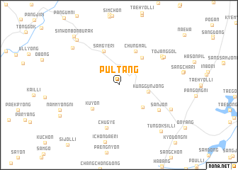
Pultang (Ulsan, Korea, South)Pultang is a town in the Ulsan region of Korea, South. An overview map of the region around Pultang is displayed below.
regional and 3d topo map of Pultang, Korea, South ::
Pultang airports ::
The nearest airport is USN - Ulsan, located 29.6 km east of Pultang.
Other airports nearby include TAE - Taegu Daegu Ab (45.1 km north west), PUS - Kimhae Gimhae Intl (49.4 km south), KPO - Pohang (54.2 km north east), YEC - Yechon Yecheon (127.6 km north west), Nearby towns ::
Kunggŭnjŏng (3.9km east) //
Chigok (4.6km south east) //
Kuyŏn (5.1km south west) //
Wahang (5.2km north east) //
Samgye-ri (5.6km north) //
Chung-mal (5.7km north) //
Chugye (6.9km south) //
Sanjŏn (6.5km south east) //
Tae-gol (7.0km north east) //
Soho-ri (7.1km north east) //
Tojang-gol (7.2km north east) //
Hyangsan (7.7km south east) //
Hwangjŏng-ni (8.3km north west) //
Naep'o (8.9km north west) //
Tŭngŏksil-li (9.1km south east) //
Sinwŏnbonburak (9.6km north west) //
[all distances 'as the bird flies' and approximate] 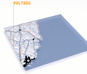 Places with similar names to Pultang, Korea, South ::
// Palidaung (MM)
// Palting (AT)
// Plitting (DE)
// Polding (DE)
// Polding (DE)
// Platanákia (GR)
// Platanákia (GR)
// Platanákia (GR)
// Platanákia (GR)
// Platanákia (GR)
Disclaimer :: Information on this page comes without warranty of any kind |
||
|
Where is Pultang? Elevation and coordinates ::
Latitude (lat): 35°37'9"N Longitude (lon): 129°1'35"E
Elevation (approx.): 432m (map arrows pan, magnifying glasses zoom) |
||
|
Visiting Pultang? Hotel/Accommodation ::
Book a hotel in Pultang Travel Guide ::
rental cars ::
car rental offers GPS waypoint ::
download a GPX waypoint (PoI) of Pultang for your GPS receiver
|
||