|
search place name
|
||
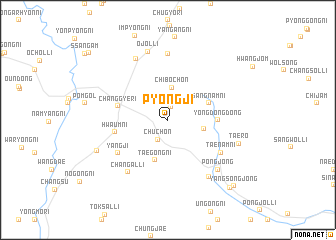
P'yŏngji (Korea, South)P'yŏngji is a town in Korea, South. An overview map of the region around P'yŏngji is displayed below.
regional and 3d topo map of P'yŏngji, Korea, South ::
P'yŏngji airports ::
The nearest airport is KUB - Kunsan Ab, located 94.3 km west of P'yŏngji.
Other airports nearby include TAE - Taegu Daegu Ab (94.8 km east), RSU - Yeosu (97.0 km south), KWJ - Kwangju Gwangju (99.5 km south west), YEC - Yechon Yecheon (120.5 km north east), Nearby towns ::
Myŏngdŏng-ni (1.5km north) //
Chuch'on (2.4km south) //
Chiboch'on (3.6km north) //
Chungnam-ni (3.4km east) //
Taegong-ni (4.6km south) //
Sangnam-ni (4.1km north east) //
Yŏngdong-dong (4.5km east) //
Changgye-ri (4.8km west) //
Hwaŭm-ni (5.0km west) //
Yangji (5.8km south west) //
Taenam-ni (6.0km south east) //
Changal-li (6.9km south west) //
Munsŏng (7.4km north) //
Maegye-ri (7.4km north west) //
Oksal-li (7.4km south east) //
Pongjŏng (7.2km south east) //
Ŏjŏl-li (7.8km north) //
Taero (6.9km south east) //
Sinjŏl-li (7.3km south west) //
Songgye-ri (9.5km south east) //
Yangsongjŏng (9.6km south east) //
Obong-ni (10.4km north west) //
[all distances 'as the bird flies' and approximate]  Places with similar names to P'yŏngji, Korea, South ::
Disclaimer :: Information on this page comes without warranty of any kind |
||
|
Where is P'yŏngji? Elevation and coordinates ::
Latitude (lat): 35°43'0"N Longitude (lon): 127°38'0"E
Elevation (approx.): 463m (map arrows pan, magnifying glasses zoom) |
||
|
Visiting P'yŏngji? Hotel/Accommodation ::
Book a hotel in P'yŏngji Travel Guide ::
rental cars ::
car rental offers GPS waypoint ::
download a GPX waypoint (PoI) of P'yŏngji for your GPS receiver
|
||