|
search place name
|
||
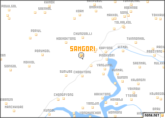
Samgŏ-ri (Kyŏnggi, Korea, South)Samgŏ-ri is a town in the Kyŏnggi region of Korea, South. An overview map of the region around Samgŏ-ri is displayed below.
regional and 3d topo map of Samgŏ-ri, Korea, South ::
Samgŏ-ri airports ::
The nearest airport is SSN - Seoul East Seoul Ab, located 51.6 km south west of Samgŏ-ri.
Other airports nearby include GMP - Seoul Gimpo (66.2 km south west), OSN - Osan Ab (89.4 km south west), SHO - Sokch'o Sokcho (105.8 km east), KAG - Kangnung Gangneung (130.3 km east), Nearby towns ::
Sangsaeng-ni (2.2km south east) //
Kyŏngbal-li (2.9km north east) //
Charit'ŏ (3.3km north east) //
Ch'ook-tong (3.9km south) //
Chungsal-li (4.8km north) //
Hoemok-tong (4.7km north west) //
Surijae (4.7km south west) //
Kap'yŏng (4.5km east) //
Pisŏkkŏri (4.4km east) //
Yangji-mal (4.6km south east) //
Karae-gol (5.1km south east) //
K'ŭn-mal (7.2km south east) //
Piryŏngdae (8.1km south east) //
Hakik-tong (9.5km south) //
Nae-ch'on (8.9km north east) //
[all distances 'as the bird flies' and approximate] 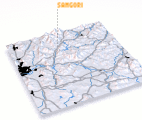 Places with similar names to Samgŏ-ri, Korea, South ::
Disclaimer :: Information on this page comes without warranty of any kind |
||
|
Where is Samgŏ-ri? Elevation and coordinates ::
Latitude (lat): 37°49'0"N Longitude (lon): 127°28'0"E
Elevation (approx.): 198m (map arrows pan, magnifying glasses zoom) |
||
|
Visiting Samgŏ-ri? Hotel/Accommodation ::
Book a hotel in Samgŏ-ri Travel Guide ::
rental cars ::
car rental offers GPS waypoint ::
download a GPX waypoint (PoI) of Samgŏ-ri for your GPS receiver
|
||