|
search place name
|
||
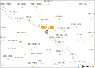
Sŏbyŏk (Kyŏngsang, Korea, South)Sŏbyŏk is a town in the Kyŏngsang region of Korea, South. An overview map of the region around Sŏbyŏk is displayed below.
regional and 3d topo map of Sŏbyŏk, Korea, South ::
Sŏbyŏk airports ::
The nearest airport is YEC - Yechon Yecheon, located 60.1 km south west of Sŏbyŏk.
Other airports nearby include KAG - Kangnung Gangneung (82.0 km north), TAE - Taegu Daegu Ab (125.9 km south), SHO - Sokch'o Sokcho (126.0 km north), KPO - Pohang (126.5 km south east), Nearby towns ::
Hangi-dong (2.7km north east) //
Sangjangam (3.3km south east) //
Hasijang (4.6km north) //
Hagŭmjŏng (4.4km north west) //
Tongnijŏng (4.8km east) //
Sangdong (5.7km south east) //
Sŏngmun-dong (5.4km east) //
Chajaktunji (6.5km south west) //
Sigŏri (7.3km south) //
Naettŭl (6.9km north east) //
Mulchip (6.8km west) //
Kyŏltan (7.9km south west) //
Choje (8.0km north west) //
Sangjo (8.8km south east) //
Kongse-dong (8.3km south east) //
Taech'ujŏng (9.4km south) //
Sŏdang-gol (9.0km south east) //
Sŏnp'yŏng-dong (9.1km south east) //
Anhwanghae (10.7km south west) //
[all distances 'as the bird flies' and approximate] 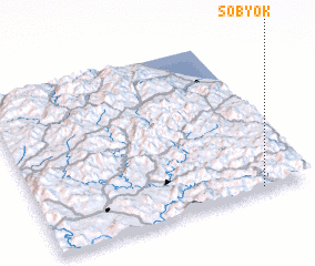 Places with similar names to Sŏbyŏk, Korea, South ::
// Sibyaki (BY)
Disclaimer :: Information on this page comes without warranty of any kind |
||
|
Where is Sŏbyŏk? Elevation and coordinates ::
Latitude (lat): 37°1'16"N Longitude (lon): 128°49'24"E
Elevation (approx.): 522m (map arrows pan, magnifying glasses zoom) |
||
|
Visiting Sŏbyŏk? Hotel/Accommodation ::
Book a hotel in Sŏbyŏk Travel Guide ::
rental cars ::
car rental offers GPS waypoint ::
download a GPX waypoint (PoI) of Sŏbyŏk for your GPS receiver
|
||