|
search place name
|
||
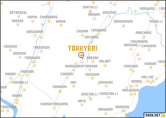
Tŏkkye-ri (Kyŏngsang, Korea, South)Tŏkkye-ri is a town in the Kyŏngsang region of Korea, South. An overview map of the region around Tŏkkye-ri is displayed below.
regional and 3d topo map of Tŏkkye-ri, Korea, South ::
Tŏkkye-ri airports ::
The nearest airport is PUS - Kimhae Gimhae Intl, located 28.9 km south west of Tŏkkye-ri.
Other airports nearby include USN - Ulsan (30.5 km north east), KPO - Pohang (72.5 km north), TAE - Taegu Daegu Ab (73.2 km north west), TSJ - Tsushima (121.7 km south), Nearby towns ::
Wŏlla (0.7km south) //
Wŏlp'yŏng-ni (1.7km south west) //
Maegok (2.0km east) //
Myŏnggong-ni (2.7km north east) //
Pyŏngsan (2.8km south east) //
Hwangdari (3.0km south west) //
Ungsang (4.0km north) //
Sŏch'ang (4.4km north) //
Yongsu-ri (4.7km south) //
Nŏlbat (4.3km east) //
Chunam (5.4km north) //
Ch'anggi (5.2km south west) //
Talsan (6.2km south east) //
Imgi (6.4km south) //
Yongdang (6.4km north east) //
Panggok (7.5km south east) //
Yŏrang-ni (8.4km south west) //
Yŏngch'ŏn (8.5km south west) //
Ungch'ŏl-li (9.0km south) //
Sanha (8.7km north west) //
Yongch'ŏl-li (10.0km south east) //
Chungbang (10.7km north west) //
[all distances 'as the bird flies' and approximate] 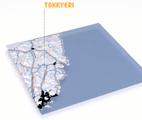 Places with similar names to Tŏkkye-ri, Korea, South ::
Disclaimer :: Information on this page comes without warranty of any kind |
||
|
Where is Tŏkkye-ri? Elevation and coordinates ::
Latitude (lat): 35°22'20"N Longitude (lon): 129°9'9"E
Elevation (approx.): 134m (map arrows pan, magnifying glasses zoom) |
||
|
Visiting Tŏkkye-ri? Hotel/Accommodation ::
Book a hotel in Tŏkkye-ri Travel Guide ::
rental cars ::
car rental offers GPS waypoint ::
download a GPX waypoint (PoI) of Tŏkkye-ri for your GPS receiver
|
||