|
search place name
|
||
Yongsugok (Kyŏngsang, Korea, South)Yongsugok is a town in the Kyŏngsang region of Korea, South. An overview map of the region around Yongsugok is displayed below.
regional and 3d topo map of Yongsugok, Korea, South ::

Yongsugok airports ::
The nearest airport is YEC - Yechon Yecheon, located 78.3 km west of Yongsugok.
Other airports nearby include KPO - Pohang (91.1 km south), KAG - Kangnung Gangneung (109.4 km north), TAE - Taegu Daegu Ab (111.1 km south west), USN - Ulsan (133.5 km south), Nearby towns ::
Kongsu (2.3km east) //
Palli (2.9km south) //
Kye-ri (2.5km north west) //
Anjang-gol (2.7km west) //
Saegogae (3.1km east) //
Sagok (4.2km south) //
Munsang (5.9km south west) //
Munam (5.6km south west) //
Sin'gi (6.6km south) //
Saet'ŏ (5.9km north east) //
Sebŏn-dong (5.6km east) //
Anam (6.9km north) //
Hŭnggŏri (6.1km west) //
Sinam (7.4km north) //
Chukp'a (8.6km south) //
Changp'a (8.5km south) //
Songjŏng (8.6km south) //
Taet'i (7.2km west) //
Taech'i (7.3km north west) //
Tŏkponggŏ-ri (8.3km south west) //
Tŏkponggŏri (8.3km south west) //
Sin-ch'on (7.5km south east) //
Chosŏng-ni (8.4km north west) //
Songbang (8.9km north east) //
Tokkok (9.2km south east) //
[all distances 'as the bird flies' and approximate] 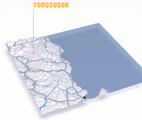 Places with similar names to Yongsugok, Korea, South :: Disclaimer :: Information on this page comes without warranty of any kind |
||
|
Where is Yongsugok? Elevation and coordinates ::
Latitude (lat): 36°47'27"N Longitude (lon): 129°12'32"E
Elevation (approx.): 510m (map arrows pan, magnifying glasses zoom) |
||
|
Visiting Yongsugok? Hotel/Accommodation ::
Book a hotel in Yongsugok Travel Guide ::
rental cars ::
car rental offers GPS waypoint ::
download a GPX waypoint (PoI) of Yongsugok for your GPS receiver
|
||