|
search place name
|
||
Macomo (Equatorial Guinea)Macomo is a town in Equatorial Guinea. An overview map of the region around Macomo is displayed below.
regional and 3d topo map of Macomo, Equatorial Guinea ::

Macomo airports ::
The nearest airport is BSG - Bata, located 20.9 km north of Macomo.
Other airports nearby include LBV - Libreville Leon M Ba (146.2 km south), BMM - Bitam (190.7 km east), OYE - Oyem (197.3 km east), Nearby towns ::
Eyamoyong (1.9km east) //
Achimelan (1.9km south) //
Ncoaekié (2.6km south west) //
Nguba (4.1km north east) //
Ndyengmendyim (4.1km south east) //
Bilon (4.1km south east) //
Sangnam (4.1km south east) //
Bidoma (4.1km south east) //
Macon (4.1km south west) //
Mayang (5.2km south east) //
Acanabot (5.2km north west) //
Ecurya (5.2km north west) //
Osuayong (5.2km north west) //
Ebomitong (5.6km south) //
Esun (5.9km east) //
Bangbira (5.9km south) //
Nsogobuot (5.9km west) //
Yobo (6.7km north east) //
Enigayong (6.7km north west) //
Aman (6.7km north west) //
Nkinfala (6.7km north west) //
Elolon (7.4km south) //
Niefang (7.4km west) //
Evoaryulu (7.6km east) //
Ocola (7.6km east) //
Movó (7.6km north) //
Bangole (7.6km south) //
Mangumala (7.6km south) //
Afan (7.6km west) //
[all distances 'as the bird flies' and approximate] 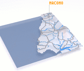 Places with similar names to Macomo, Equatorial Guinea ::
Disclaimer :: Information on this page comes without warranty of any kind |
||
|
Where is Macomo? Elevation and coordinates ::
Latitude (lat): 1°43'0"N Longitude (lon): 9°49'0"E
Elevation (approx.): 35m (map arrows pan, magnifying glasses zoom) |
||
|
Visiting Macomo? Hotel/Accommodation ::
Book a hotel in Macomo Travel Guide ::
rental cars ::
car rental offers GPS waypoint ::
download a GPX waypoint (PoI) of Macomo for your GPS receiver
|
||