|
search place name
|
||
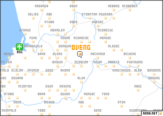
Oveng (Equatorial Guinea)Oveng is a town in Equatorial Guinea. An overview map of the region around Oveng is displayed below.
regional and 3d topo map of Oveng, Equatorial Guinea ::
Oveng airports ::
The nearest airport is BSG - Bata, located 14.4 km west of Oveng.
Other airports nearby include LBV - Libreville Leon M Ba (167.9 km south), BMM - Bitam (174.8 km east), OYE - Oyem (187.2 km east), SSG - Malabo (247.8 km north west), Nearby towns ::
Ncoacom (1.9km south) //
Bongo (2.6km south west) //
Monte Bata (3.7km west) //
Ncomococ (3.7km north) //
Machinda (3.7km east) //
Bimbon (4.1km south west) //
Bisabicuna (4.1km south west) //
Benvene (4.1km north west) //
Ayeenin (4.1km north west) //
Sanduma (4.1km north west) //
Micán (4.1km south east) //
Ecoguon (4.1km north east) //
Bindele (5.2km south west) //
Akora (5.2km south west) //
Ngono (5.2km north west) //
Olong (5.6km west) //
Alum (5.6km south) //
Bindún (5.9km west) //
Eyiyielon (5.9km east) //
Biconete (5.9km east) //
Ofos (5.9km west) //
Alum (6.7km north west) //
Andum (6.7km north west) //
Anguec (6.7km north east) //
Encuantang (6.7km north east) //
Mondoc (6.7km north east) //
Acom (7.4km west) //
Acoga (7.6km south) //
Asem (7.6km north) //
[all distances 'as the bird flies' and approximate]  Places with similar names to Oveng, Equatorial Guinea ::
Disclaimer :: Information on this page comes without warranty of any kind |
||
|
Where is Oveng? Elevation and coordinates ::
Latitude (lat): 1°53'0"N Longitude (lon): 9°56'0"E
Elevation (approx.): 180m (map arrows pan, magnifying glasses zoom) |
||
|
Visiting Oveng? Hotel/Accommodation ::
Book a hotel in Oveng Travel Guide ::
rental cars ::
car rental offers GPS waypoint ::
download a GPX waypoint (PoI) of Oveng for your GPS receiver
|
||