|
search place name
|
||
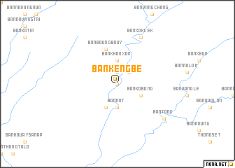
Ban Kèngbè (Laos)Ban Kèngbè is a town in Laos. An overview map of the region around Ban Kèngbè is displayed below.
regional and 3d topo map of Ban Kèngbè, Laos ::
Ban Kèngbè airports ::
The nearest airport is SNO - Sakon Nakhon, located 151.9 km south west of Ban Kèngbè.
Other airports nearby include ZVK - Savannakhet (158.7 km south west), Nearby towns ::
Ban Phak Phèo (0.0km north) //
Ban Thaphaiban (1.9km north) //
Ban Mai (2.6km north east) //
Ban Khamxom (3.7km north) //
Ban Nat (3.7km south) //
Ban Kobông (4.0km south east) //
Ban Koua Po (4.1km south west) //
Ban Boungbouy (5.8km north) //
Ban Duangphou (8.2km north east) //
Ban Xok Lèk (8.2km north east) //
Ban Chounnou (9.0km south east) //
Ban Tong (9.0km south east) //
[all distances 'as the bird flies' and approximate] 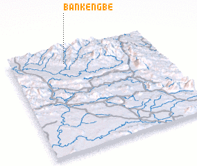 Places with similar names to Ban Kèngbè, Laos ::
// Ban Kon Kaeo (1) (TH)
// Ban Kangba (LA)
// Ban Kang (1) (LA)
// Ban Kèngbay (LA)
// Ban Nakang (1) (LA)
// Bản Cang (1) (VN)
Disclaimer :: Information on this page comes without warranty of any kind |
||
|
Where is Ban Kèngbè? Elevation and coordinates ::
Latitude (lat): 17°52'0"N Longitude (lon): 105°22'0"E
Elevation (approx.): 549m (map arrows pan, magnifying glasses zoom) |
||
|
Visiting Ban Kèngbè? Hotel/Accommodation ::
Book a hotel in Ban Kèngbè Travel Guide ::
Buy a travel guide for Laos rental cars ::
car rental offers GPS waypoint ::
download a GPX waypoint (PoI) of Ban Kèngbè for your GPS receiver
|
||