|
search place name
|
||
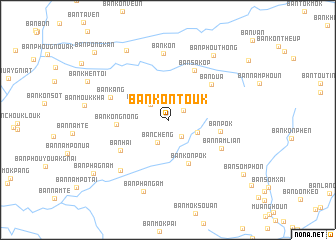
Ban Kontouk (Oudômxai, Laos)Ban Kontouk is a town in the Oudômxai region of Laos. An overview map of the region around Ban Kontouk is displayed below.
regional and 3d topo map of Ban Kontouk, Laos ::
Ban Kontouk airports ::
The nearest airport is LPQ - Luang Prabang Luang Phabang Intl, located 93.3 km south east of Ban Kontouk.
Other airports nearby include THL - Tachilek Tachileik (149.8 km west), KET - Kengtung (213.2 km north west), LPT - Lampang (292.0 km south west), Nearby towns ::
Ban Dôngbang (2.0km north east) //
Ban Phakham (2.4km south east) //
Ban Môkkachok (2.5km north west) //
Ban Chèng (2.7km south west) //
Ban Mouangkham (3.4km south east) //
Ban Konpok (5.3km south east) //
Ban Kon-Gnong (5.4km west) //
Ban Pok (5.6km east) //
Ban Sakôp (6.2km north east) //
Ban Dua (6.0km north east) //
Ban Hai (6.0km south west) //
Ban Namlian (6.4km south east) //
Ban Kang (6.5km north west) //
Ban Kon (7.4km north) //
Ban Hay-Tai (7.5km south west) //
Ban Phangam (8.4km south) //
Ban Phouthong (8.7km north east) //
Ban Chanmai (8.9km north west) //
Ban Phagnam (9.8km south west) //
Ban Sômphon (10.0km south east) //
Ban Pôngkan (10.8km north west) //
[all distances 'as the bird flies' and approximate]  Places with similar names to Ban Kontouk, Laos :: Disclaimer :: Information on this page comes without warranty of any kind |
||
|
Where is Ban Kontouk? Elevation and coordinates ::
Latitude (lat): 20°14'40"N Longitude (lon): 101°20'52"E
Elevation (approx.): 1068m (map arrows pan, magnifying glasses zoom) |
||
|
Visiting Ban Kontouk? Hotel/Accommodation ::
Book a hotel in Ban Kontouk Travel Guide ::
Buy a travel guide for Laos rental cars ::
car rental offers GPS waypoint ::
download a GPX waypoint (PoI) of Ban Kontouk for your GPS receiver
|
||