|
search place name
|
||
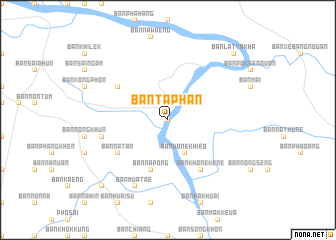
Ban Taphan (Salavan, Laos)Ban Taphan is a town in the Salavan region of Laos. An overview map of the region around Ban Taphan is displayed below.
regional and 3d topo map of Ban Taphan, Laos ::
Ban Taphan airports ::
The nearest airport is ZVK - Savannakhet, located 93.5 km north west of Ban Taphan.
Other airports nearby include PKZ - Pakse (100.0 km south east), SNO - Sakon Nakhon (191.8 km north west), Nearby towns ::
Ban Pak Saeng (0.0km north) //
Ban Na Sai (2.6km north east) //
Ban Nong Nok Khian (4.0km north west) //
Ban Bok (4.0km north west) //
Ban Done Khieo (4.1km south east) //
Ban Na Pong (5.8km south) //
Ban Na Tan (6.5km south west) //
Ban Khône Kène (6.6km south east) //
Ban Kho Noi (6.5km north west) //
Ban Na Pathao (7.4km west) //
Ban Muat Ae (8.2km south west) //
Ban Muang Som (10.3km south west) //
Ban Lat Ya Kha (10.3km north east) //
[all distances 'as the bird flies' and approximate]  Places with similar names to Ban Taphan, Laos ::
// Bannteufen (AT)
// Ban Na Ta Phan (TH)
// Bandevān (IR)
// Bandīvān (IR)
// Ban Taophan (LA)
// Ban Taphan (LA)
// Ban Tavèn (LA)
// Ban Taveun (LA)
// Bandivan (AM)
Disclaimer :: Information on this page comes without warranty of any kind |
||
|
Where is Ban Taphan? Elevation and coordinates ::
Latitude (lat): 15°56'0"N Longitude (lon): 105°21'0"E
Elevation (approx.): 106m (map arrows pan, magnifying glasses zoom) |
||
|
Visiting Ban Taphan? Hotel/Accommodation ::
Book a hotel in Ban Taphan Travel Guide ::
Buy a travel guide for Laos rental cars ::
car rental offers GPS waypoint ::
download a GPX waypoint (PoI) of Ban Taphan for your GPS receiver
|
||